[:ja]ESAの地球観測衛星Sentinel-1Bが撮影したエチオピアのダナキルデプレッションのフォールスカラーイメージです。
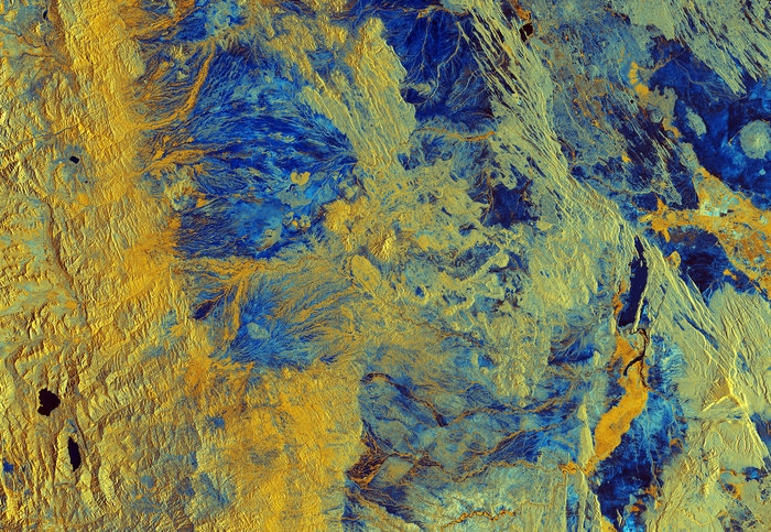
ダナキルデプレッションはアフリカ大陸東部、エチオピア北東部とエリトリア南部に広がる砂漠地帯で、アファル人の居住地であり、その高温と海抜マイナス100メートルを切るアファール盆地で知られます。その中で乾燥地帯ダロルは年間平均気温が34.4度と高く、最も暑い6~7月は最高気温が46℃以上に達します。大地溝帯(グレートリフトバレー)に位置し、陸地では噴火口が最も低いダロル火山があります。ダナキル砂漠の主産業は岩塩の採掘です。夏には気温が50℃近くになることがあり、人類が住める最も暑い場所としてギネス記録に登録されています。
地上の様子はこちらです。

参考文献: Northeast Ethiopia (Earth from Space, ESA)
地球俯瞰画像を見る: LiVEARTH
[Earthview Wonders] No.1005: Danakil Depression🇪🇹
ESA’s Sentinel-1B captured Danakil Depression in false color image.
The Danakil Depression is the northern part of the Afar Depression in Ethiopia at about 125m below sea level, a geological depression that has resulted from the divergence of three tectonic plates in the Horn of Africa. Dallol, to the north of Semera in Ethiopia’s Danakil Depression, is frequently cited as one of the hottest inhabited places on Earth. Dallol as an avearage of 34.4C year-round, and the area receiving just 100–200 mm rainfall a year, conditions are thought to be amongst the most inhospitable in the world.
The local scenery on the ground is as follows.
Reference: Northeast Ethiopia (Earth from Space, ESA)
See earthview photo gallery: LiVEARTH[:en][Earthview Wonders] No.1005: Danakil Depression🇪🇹
ESA’s Sentinel-1B captured Danakil Depression in false color image.
The Danakil Depression is the northern part of the Afar Depression in Ethiopia at about 125m below sea level, a geological depression that has resulted from the divergence of three tectonic plates in the Horn of Africa. Dallol, to the north of Semera in Ethiopia’s Danakil Depression, is frequently cited as one of the hottest inhabited places on Earth. Dallol as an avearage of 34.4C year-round, and the area receiving just 100–200 mm rainfall a year, conditions are thought to be amongst the most inhospitable in the world.
The local scenery on the ground is as follows.
Reference: Northeast Ethiopia (Earth from Space, ESA)
See earthview photo gallery: LiVEARTH[:]