[:ja]NASAの地球観測衛星Terraが撮影したグリーンランドのネアズ海峡(ナレス海峡)です。例年、融氷の時期は異なりますが、2019年は5月には流氷が形成されていました。画像の通り、2020年はまだ凍っています。
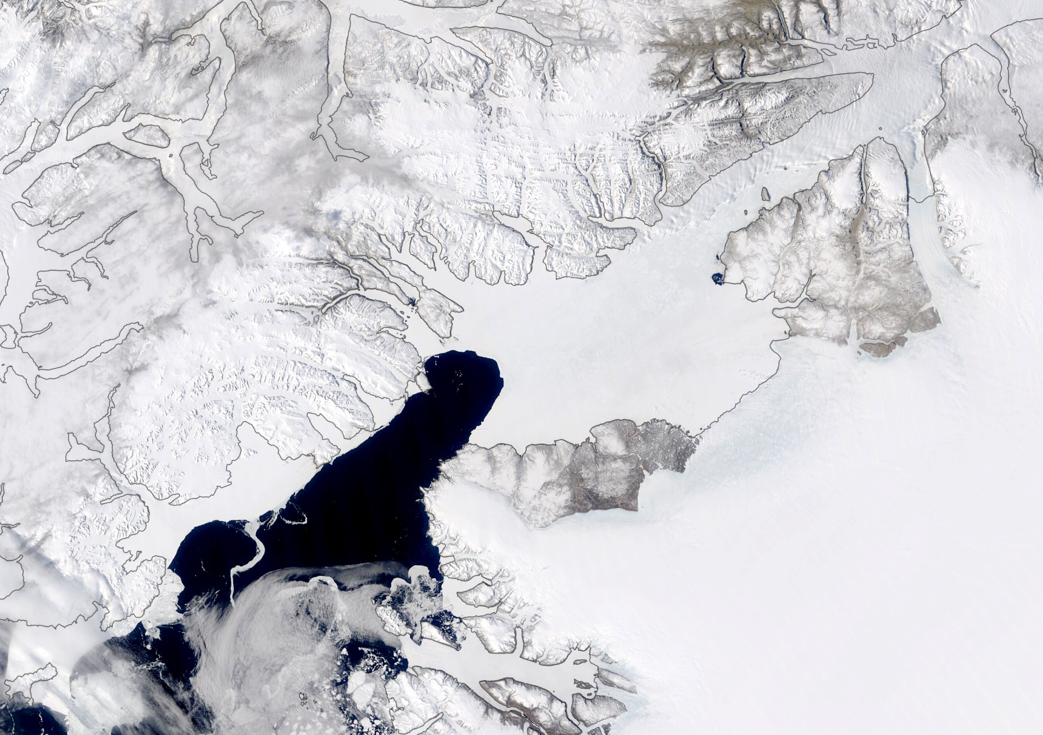
バフィン湾の一部であるネアズ海峡は、カナダ領エルズミーア島とグリーンランドの間の海峡で、デーヴィス海峡とリンカーン海を結んでいます。名前はイギリスの海軍士官ジョージ・ネアズに因み、1964年にデンマーク政府とカナダ政府によって名前が決められました。この海峡やその周辺海域は、海氷などにより船が航行するには非常に危険な海域ですが、8月は砕氷船により航行可能になります。1948年以前はケイン湾の北まで無事に航海できた記録がある船は5隻だけです。海峡内にある小さな島ハンス島はカナダとデンマークが共に領有権を主張しています。
地上の様子はこちらです。

参考文献: Ice Arch Persists Despite Warm Arctic (NASA Earth Observatory)
地球俯瞰画像を見る: LiVEARTH
[Earthview Wonders] No.1044: Nares Strait🇬🇱🇩🇰🇨🇦
NASA’s Terra satellite captured Nares Strait. The timing of ice melting differs each year. In 2019 the ice arch collapsed early, crumbling in mid-April and allowing ice to flow freely by May. As can be seen from the image, The ice arch in 2020 has proved to be more stable.
Nares Strait is a waterway between Ellesmere Island and Greenland that connects the northern part of Baffin Bay with the Lincoln Sea. Nares strait has a nearly permanent current from the north, powered by the Beaufort Gyre, making it harder to traverse for ships coming from the south. In 1964, its name was agreed by the Danish and Canadian governments, to be derived from the British naval officer George Strong Nares. The strait and neighbouring waters are usually hazardous for navigation and shipping. During August, however, it is usually navigable by icebreakers. Hans Island, a tiny island lying within the strait, is claimed by both Denmark (on behalf of Greenland) and Canada.
The local scenery on the ground is as follows.
Reference: Ice Arch Persists Despite Warm Arctic (NASA Earth Observatory)
See earthview photo gallery: LiVEARTH[:en][Earthview Wonders] No.1044: Nares Strait🇬🇱🇩🇰🇨🇦
NASA’s Terra satellite captured Nares Strait. The timing of ice melting differs each year. In 2019 the ice arch collapsed early, crumbling in mid-April and allowing ice to flow freely by May. As can be seen from the image, The ice arch in 2020 has proved to be more stable.
Nares Strait is a waterway between Ellesmere Island and Greenland that connects the northern part of Baffin Bay with the Lincoln Sea. Nares strait has a nearly permanent current from the north, powered by the Beaufort Gyre, making it harder to traverse for ships coming from the south. In 1964, its name was agreed by the Danish and Canadian governments, to be derived from the British naval officer George Strong Nares. The strait and neighbouring waters are usually hazardous for navigation and shipping. During August, however, it is usually navigable by icebreakers. Hans Island, a tiny island lying within the strait, is claimed by both Denmark (on behalf of Greenland) and Canada.
The local scenery on the ground is as follows.
Reference: Ice Arch Persists Despite Warm Arctic (NASA Earth Observatory)
See earthview photo gallery: LiVEARTH[:]