[:ja]NASAの地球観測衛星Landsat 8が撮影した中国、長江中流にある世界最大級の三峡ダムです。
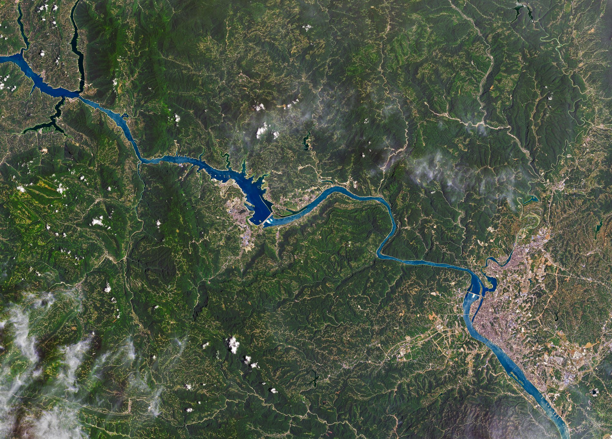
6月から断続的に続く大雨、最近の大雨で、湖北省宜昌市の三峡ダムの水位が上昇しています。長江中流流域では大雨により400以上の河川で洪水が起き、200万人以上が避難するなど被害が拡大しています。三峡ダムは2006年5月に完成した世界最大級のダムで、水力発電会社として世界でも有数の規模を持つ国営企業の中国長江三峡集団が運営しています。三峡ダムでは下流域で河川の氾濫などを避けるために貯水量を増やしていましたが、制限水位145mを上回る状況が6月中旬から続いたため、6月末には今年初めて放水を実施、直近7月22日時点でダムの水位は162.22mとなっています。
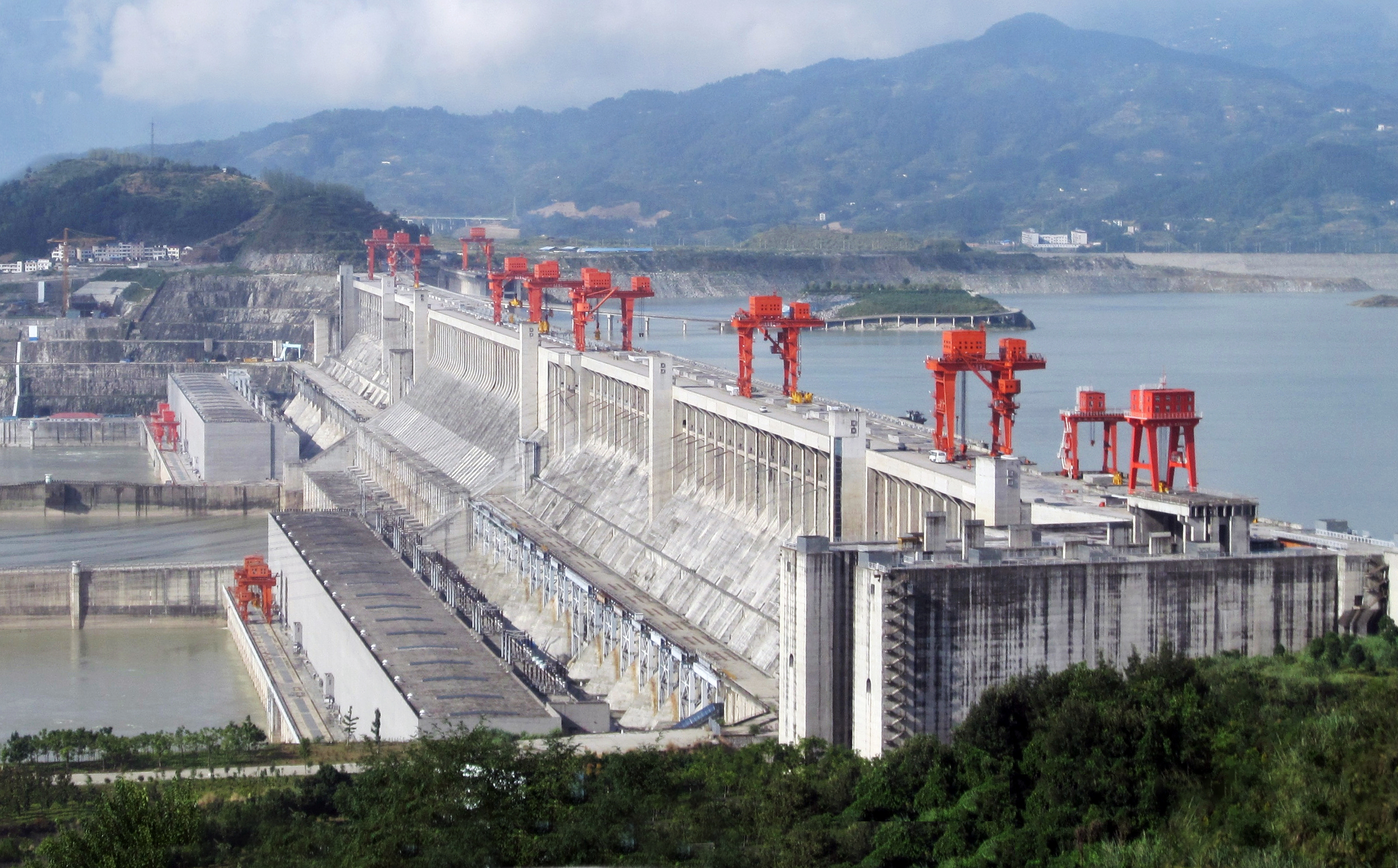
地上の様子はこちらです。
参考文献: Yangtze Dams Spill Water (NASA Earth Observatory)
地球俯瞰画像を見る: LiVEARTH
[Earthview Wonders] No.1078: Three Gorges Dam🇨🇳
NASA’s Landsat 8 satellite captured Three Gorges Dam, China.
Continuous excessive rainfall since June has caused flooding within the Yangtze River Basin, and has displaced millions of people. One of the biggest concerns relating to the rainfall has been the situation of the Three Gorges Dam which was pushed to record high water level. Despite discharging water after surpassing the standard level of 145m, the water level has risen to 162.22m by July 22. Yangtze River is Asia’s longest, winding 6,300km through China. Together with its network of tributaries and lakes, the river system has undergone significant development as a means to generate power, store water for drinking and irrigation, and control flooding.
The local scenery on the ground is as follows.
Reference: Yangtze Dams Spill Water (NASA Earth Observatory)
See earthview photo gallery: LiVEARTH[:en][Earthview Wonders] No.1078: Three Gorges Dam🇨🇳
NASA’s Landsat 8 satellite captured Three Gorges Dam, China.
Continuous excessive rainfall since June has caused flooding within the Yangtze River Basin, and has displaced millions of people. One of the biggest concerns relating to the rainfall has been the situation of the Three Gorges Dam which was pushed to record high water level. Despite discharging water after surpassing the standard level of 145m, the water level has risen to 162.22m by July 22. Yangtze River is Asia’s longest, winding 6,300km through China. Together with its network of tributaries and lakes, the river system has undergone significant development as a means to generate power, store water for drinking and irrigation, and control flooding.
The local scenery on the ground is as follows.
Reference: Yangtze Dams Spill Water (NASA Earth Observatory)
See earthview photo gallery: LiVEARTH[:]