[:ja]ルカ・パルミタノ宇宙飛行士がISSから撮影したチベットのラサです。
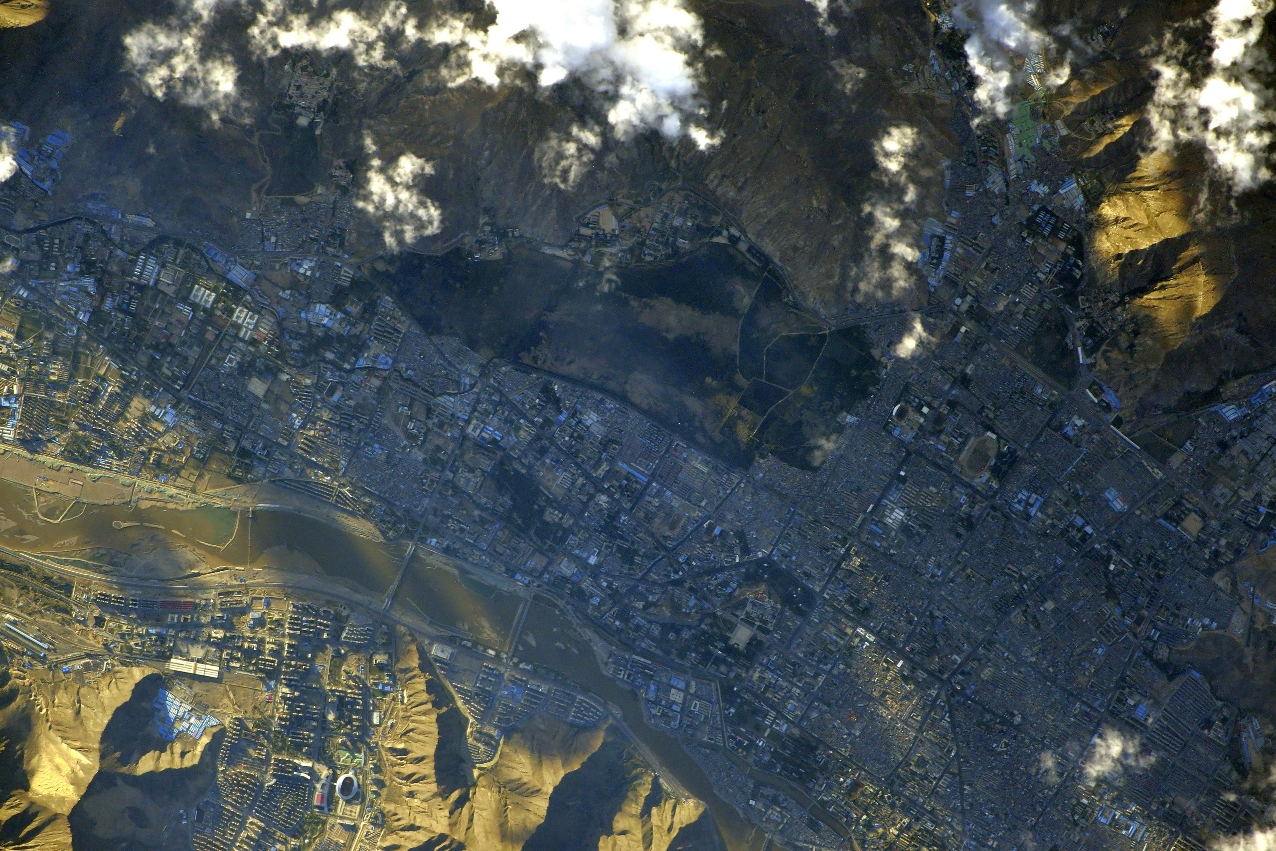
ラサは、吐蕃時代の7世紀に成立したチベットの古都。吐蕃時代(7世紀 – 842年)やダライ・ラマ政権時代(1642年 – 1959年)に政権の本拠地がおかれて政治的中枢となり、また政権の変遷をこえて文化的中枢であり続けました。チベット、モンゴル、満州などの諸民族から構成されるチベット仏教文化圏の中枢でもあります。1960年、中国政府により、古都ラサと郊外、ウー地方北部諸県を領域とする地級市拉薩市(ラサ市)が設置されました。チベット中央部、ヤルンツァンポ河流域に位置し、海抜3,700mの高地にあります。
地上の様子はこちらです。

チベット高原の様子はこちらです。

参考文献: Luca Parmitano’s Tweet
地球俯瞰画像を見る: LiVEARTH
[Earthview Wonders] No.1083: Lhasa, Tibet
Astronaut Luca Parmitano captured from ISS Lhasa, Tibet.
Lhasa is the administrative capital of Lhasa City in the Tibet Autonomous Region of China. Lhasa is the second most populous urban area on the Tibetan Plateau after Xining and, at an altitude of 3,656m, Lhasa is one of the highest cities in the world. The city has been the religious and administrative capital of Tibet since the mid-17th century. It contains many culturally significant Tibetan Buddhist sites such as the Potala Palace, Jokhang Temple and Norbulingka Palaces. The city boundaries roughly correspond to the basin of the Lhasa River, a major tributary of the Yarlung Tsangpo River. It lies on the Lhasa terrane, the last unit of crust to accrete to the Eurasian plate before the continent of India collided with Asia about 50 million years ago and pushed up the Himalayas.
The local scenery on the ground of Lhasa is as follows.
This is the scenery of the Tibetan Plateau.
Reference: Luca Parmitano’s Tweet
See earthview photo gallery: LiVEARTH[:en][Earthview Wonders] No.1083: Lhasa, Tibet
Astronaut Luca Parmitano captured from ISS Lhasa, Tibet.
Lhasa is the administrative capital of Lhasa City in the Tibet Autonomous Region of China. Lhasa is the second most populous urban area on the Tibetan Plateau after Xining and, at an altitude of 3,656m, Lhasa is one of the highest cities in the world. The city has been the religious and administrative capital of Tibet since the mid-17th century. It contains many culturally significant Tibetan Buddhist sites such as the Potala Palace, Jokhang Temple and Norbulingka Palaces. The city boundaries roughly correspond to the basin of the Lhasa River, a major tributary of the Yarlung Tsangpo River. It lies on the Lhasa terrane, the last unit of crust to accrete to the Eurasian plate before the continent of India collided with Asia about 50 million years ago and pushed up the Himalayas.
The local scenery on the ground of Lhasa is as follows.
This is the scenery of the Tibetan Plateau.
Reference: Luca Parmitano’s Tweet
See earthview photo gallery: LiVEARTH[:]