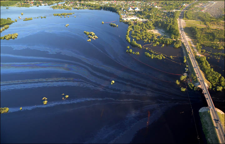
[:ja]NASAの地球観測衛星Aquaが撮影した、ロシアのオビ川流域です。オビ川は全長5,570kmで世界第5位を誇り、流域の西シベリア低地は天然ガスや油田で有名で、ロシアの原油・天然ガス産出量の3分の2を占めるとされます。

天然ガスの大部分は北極圏のヤマル半島やギダン半島に集まる一方、油田は西シベリア低地に集中しています。
残念なことに、2015年6月に、原油パイプラインから漏洩が起こり、オビ川及びネフテユガンスク市の水が汚染されました。
参考文献: Oil Fields Along the Ob River (Earth Observatory, NASA)
ウェブ地球儀で地球俯瞰画像を見る: LiVEARTH
[Earthview Wonders] No.111: Oil Fields Along the Ob River
NASA’s Aqua satellite captured Russia’s Ob River. Ob River is 5,570km long and the 5th longest in the world. Its river basin includes the West Siberian Basin which contributes about two-thirds of the country’s crude oil and natural gas output.
While most of the gas fields are clustered along the Yamal and Gydan Peninsulas, this oil fields are concentrated in the West Siberian Basin.
Unfortunately, in June 2015, a leak in an oil pipeline blackened the Ob River and contaminated tap water in the city of Nefteyugansk.
Reference: Oil Fields Along the Ob River (Earth Observatory, NASA)
See earthview photo gallery with web-globe: LiVEARTH[:en][Earthview Wonders] No.111: Oil Fields Along the Ob River
NASA’s Aqua satellite captured Russia’s Ob River. Ob River is 5,570km long and the 5th longest in the world. Its river basin includes the West Siberian Basin which contributes about two-thirds of the country’s crude oil and natural gas output.
While most of the gas fields are clustered along the Yamal and Gydan Peninsulas, this oil fields are concentrated in the West Siberian Basin.
Unfortunately, in June 2015, a leak in an oil pipeline blackened the Ob River and contaminated tap water in the city of Nefteyugansk.
Reference: Oil Fields Along the Ob River (Earth Observatory, NASA)
See earthview photo gallery with web-globe: LiVEARTH[:]