[:ja]ルカ・パルミタノ宇宙飛行士がISSから撮影した米ニューヨークです。
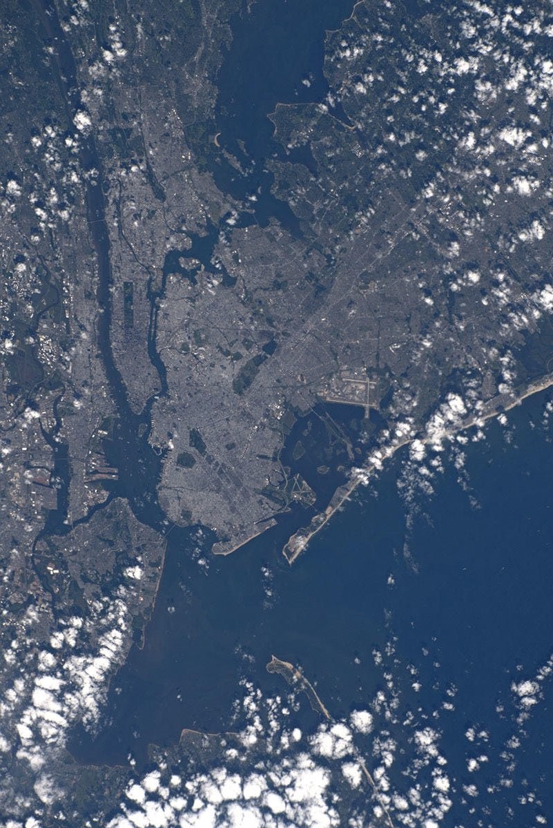
ニューヨーク市はブロンクス、ブルックリン、マンハッタン、クイーンズ、スタテンアイランドという5つの行政区に分けられます。ハドソン川対岸のニュージャージー州ニューアークやジャージーシティ、本土側のヨンカーズやニューロシェル、ロングアイランド、コネチカット州の一部を含む広域都市圏は2200万人を超えます。ニューヨークの大部分は、マンハッタン、スタテンアイランド、ロングアイランドという3つの島の上にあるため、陸地面積が狭く、人口密度が高い原因となっています。ハドソン川によってニュージャージー州とニューヨーク市が、イースト川によって、ブロンクス、マンハッタン、ロングアイランドが隔てられています。市の地形にはかなり人の手が加わっており、オランダ植民地時代から、川岸に沿って大規模な埋め立てが進められました。埋め立てがもっとも進んだのはロウアー・マンハッタンであり、1970年代から1980年代にかけてバッテリー・パーク・シティの開発が行われました。また、マンハッタンはもとは丘の多い地形で、非常にしっかりとした岩盤(マンハッタン片岩)が地下にあるため、超高層ビルの建設に適した地形です。
地上の様子はこちらです。

参考文献: Luca Parmitano’s Tweet
地球俯瞰画像を見る: LiVEARTH
[Earthview Wonders] No.1148: New York🇺🇸
Astronaut Luca Parmitano captured from ISS New York City, U.S.
During the Wisconsin glaciation, 75,000 to 11,000 years ago, the New York City area was situated at the edge of a large ice sheet over 610m in depth. Today New York City is located at the mouth of the Hudson River, which feeds into a naturally sheltered harbor and then into the Atlantic Ocean. Most of the city is built on the three islands of Long Island, Manhattan, and Staten Island. The Hudson River separates New York City from New Jersey while the East River and the Harlem River separate the Bronx and Manhattan from Long Island. The city’s land has been altered substantially by human intervention, with considerable land reclamation along the waterfronts since Dutch colonial times; reclamation is most prominent in Lower Manhattan, with developments such as Battery Park City in the 1970s and 1980s.
The local scenery on the ground is as follows.
Reference: Luca Parmitano’s Tweet
See earthview photo gallery: LiVEARTH[:en][Earthview Wonders] No.1148: New York🇺🇸
Astronaut Luca Parmitano captured from ISS New York City, U.S.
During the Wisconsin glaciation, 75,000 to 11,000 years ago, the New York City area was situated at the edge of a large ice sheet over 610m in depth. Today New York City is located at the mouth of the Hudson River, which feeds into a naturally sheltered harbor and then into the Atlantic Ocean. Most of the city is built on the three islands of Long Island, Manhattan, and Staten Island. The Hudson River separates New York City from New Jersey while the East River and the Harlem River separate the Bronx and Manhattan from Long Island. The city’s land has been altered substantially by human intervention, with considerable land reclamation along the waterfronts since Dutch colonial times; reclamation is most prominent in Lower Manhattan, with developments such as Battery Park City in the 1970s and 1980s.
The local scenery on the ground is as follows.
Reference: Luca Parmitano’s Tweet
See earthview photo gallery: LiVEARTH[:]