[:ja]ルカ・パルミタノ宇宙飛行士がISSから撮影したトルクメニスタンのカラ・ボガス・ゴル湾です。
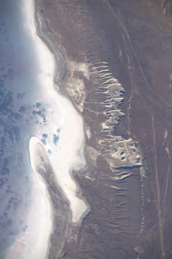
カラボガスゴル湾、カラボガズゴル湾 (Zaliv Kara-Bogaz-Gol) は、中央アジアのカスピ海東部にある湾です。カスピ海本体とは砂州で分断され、狭い海峡を通じて接続しているため、独立した潟湖として扱われることもあります。「カラ・ボガス・ゴル」は、トルコ語で「黒い潟湖」の意味です。カスピ海には幾つかの湾が存在するものの、それら湾の中で1番大きな湾がカラボガスゴル湾です。この湾にはカスピ海から水が流れ込んでくることが知られています。カスピ海から流れ込んできた水は、もはやどこにも流出する場所が無いために、カラボガスゴル湾の塩分濃度は元々高く、カスピ海からの流れに乗ってこの湾へと入ってきてしまった魚は、その塩分濃度のためにすぐに死んでしまうことが知られていました。そして、このカラボガスゴル湾という水の流出先があるために、カスピ海の塩分濃度は、比較的低く抑えられてきた側面があります。
地上の様子はこちらです。

参考文献: Luca Parmitano’s Tweet
地球俯瞰画像を見る: LiVEARTH
[Earthview Wonders] No.1212: Kara-Bogaz-Gol, Turkmenistan🇹🇲
Astronaut Luca Parmitano captured from ISS Kara-Bogaz-Gol, Turkmenistan.
The Garabogazköl Aylagy or Kara-Bogaz-Gol is a shallow water-filled depression in the northwestern corner of Turkmenistan. It forms a lagoon of the Caspian Sea and has a variable surface area, being about 18,000 km2. The Caspian Sea proper sits immediately to the west, mostly divorced by a narrow, rocky ridge having a very narrow opening through which the Caspian waters flow, overwhelmingly, into it. There is likely to be a subterreanean highly saline flow, if only when evaporation is less fierce in winter, as in the case of the Turkish Straits year-round. The lagoon’s volume fluctuates seasonally, accentuated by its salt evaporation ponds and natural counter part surrounding, seasonally dry salt pans. The salinity of the lagoon averages about 35%, compared to the Caspian Sea’s 1.2%, and 3–4% for the bulk of the world’s oceans. Because of the exceptionally high salinity, comparable to the Dead Sea, it has practically no marine vegetation.
The local scenery on the ground is as follows.
Reference: Luca Parmitano’s Tweet
See earthview photo gallery: LiVEARTH[:]