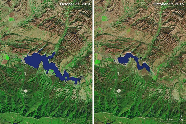
[:ja]南カリフォルニアでは長引く干ばつの影響により、栽培に必要な水が少量で済む作物に変える農家が出てきています。NASAのLandsat 8が撮影した、ロサンゼルスの西にあるカチューマ湖の比較画像です。この3年の間に湖は縮小し、最大容量の7%しかありません。
セントラルバレーでは、干ばつにより、地下水の利用を増加させた結果、地盤沈下が急速に進んでいます。また、取水制限を課している町もあります。
地上の様子はこちらです。
参考文献: Drought Continues to Grip Southern California
ウェブ地球儀で地球俯瞰画像を見る: LiVEARTH
[Earthview Wonders] No.130: Drought in California
Drought in Southern California has inflicted serious damage to the agrea, and some farmers have had to switch to crops that require less water. NASA’s Landsat 8 captured comparative photos of Lake Cachuma, in the west of Los Angeles.
To compensate for the lack of surface water, the use of groundwater increased which resulted in land sinking in the Central Valley at an unusually rapid rate. Further, some towns and cities have put strict conservation measures in place to minimize water use.
Drought-hit Lake Cachuma on the ground looks like this.
Reference: Drought Continues to Grip Southern California
See earthview photo gallery with web-globe: LiVEARTH[:en][Earthview Wonders] No.130: Drought in California
Drought in Southern California has inflicted serious damage to the agrea, and some farmers have had to switch to crops that require less water. NASA’s Landsat 8 captured comparative photos of Lake Cachuma, in the west of Los Angeles.
To compensate for the lack of surface water, the use of groundwater increased which resulted in land sinking in the Central Valley at an unusually rapid rate. Further, some towns and cities have put strict conservation measures in place to minimize water use.
Drought-hit Lake Cachuma on the ground looks like this.
Reference: Drought Continues to Grip Southern California
See earthview photo gallery with web-globe: LiVEARTH[:]