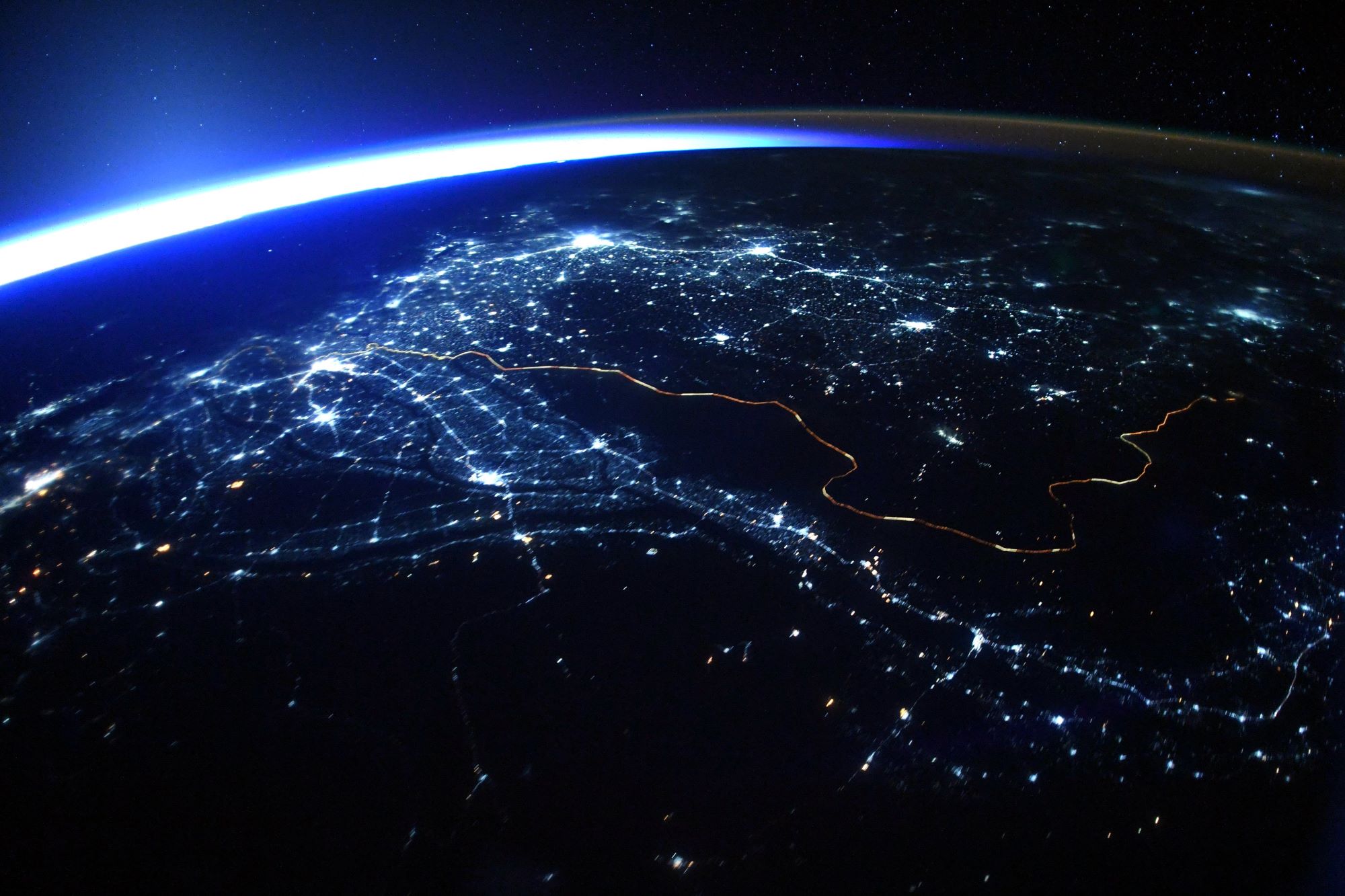
[:ja]トマ・ペスケ宇宙飛行士がISSから撮影したパキスタンとインドの国境です。インドが国境に沿って約5万本の柱に15万個の投光照明を設置しており、夜間には宇宙からも国境線を確認できます。画像はパキスタン側からインドを眺望しており、ジャイサルメール、ジョードプル、ジャイプル、ニューデリーなどの大都市が見えています。
インド=パキスタン国境は、北はカシミールにおける実効支配地域の境界である管理ライン(LoC)に始まり、南はゼロ・ポイント駅まで続きます。公共放送サービスPBSの数値によれば、国境の全長は3,323kmにもおよびます。原型は1947年のインド・パキスタン分離独立の際に制定されたラドクリフ線で、主要な都市部や人を寄せ付けない砂漠など様々な地形を横断します。イギリス領インド帝国からのインド・パキスタン分離独立以来、両国間では国境を挟んだ多数の紛争や戦争が起きています。世界で最も関係が複雑な国境の一つであり、2011年の『フォーリン・ポリシー』の記事には、世界で最も危険な国境の一つと書かれています。
地上の様子はこちらです。

参考文献: Thomas Pesquet’s Tweet
地球俯瞰画像を見る: LiVEARTH
[Earthview Wonders] No.1398: Border Between Pakistan and India🇵🇰🇮🇳
Astronaut Thomas Pesquet captured from ISS the border between Pakistan and India. It can be seen from space at night due to the 150,000 flood lights installed by India on about 50,000 poles. The image shows the view from Pakistan, looking at India. Cities such as Jaisalmer, Jodhpur, Jaipur and New Delhi can be recognized.
The India–Pakistan Border’s total length is 3,323km, according to PBS. The border runs from the Line of Control (LoC), which separates Indian-administered Kashmir from Pakistani-administered Kashmir in the north, to Sir Creek in Rann of Kutch between the Indian state of Gujarat and the Sindh province of Pakistan in the south. Drafted and created based upon the Radcliffe line in 1947, the border, which divides Pakistan and India from each other, traverses a variety of terrains ranging from major urban areas to inhospitable deserts. Since the independence of India and Pakistan (see British India), the border has been a site of numerous conflicts and wars between each country, and is one of the most contested borders in the world.
The local scenery on the ground is as follows.
Reference: Thomas Pesquet’s Tweet
See earthview photo gallery: LiVEARTH[:]