[:ja]NASAの地球観測衛星Landsat 8が撮影した雲海の中のベスビオ山(ヴェスヴィオ山)です。
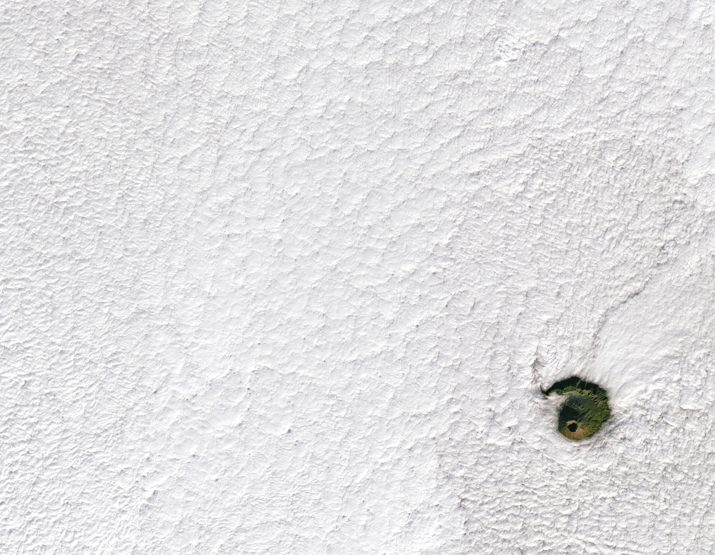
ヴェスヴィオ山は、イタリア・カンパニア州にある火山で、ナポリから東へ約9kmのナポリ湾岸にあります。現在は噴火していませんが、監視体制が敷かれています。ヴェスヴィオ山は、ソンマ山(1,132m)とよばれる外輪山が取り巻いた標高1281メートルの複合成層火山です。ローマ人にとっては紀元前73年に剣闘士スパルタクスが仲間とともに立て籠もった山として記憶されていました。西暦79年のヴェスヴィオ噴火が有名であり、この時の火砕流でポンペイ市を、土石流でヘルクラネウム(現エルコラーノ)を埋没させました。以降数十回の噴火を繰り返しています。
地上の様子はこちらです。

参考文献: A View of Vesuvius (NASA Earth Observatory)
地球俯瞰画像を見る: LiVEARTH
[Earthview Wonders] No.1467: Vesuvius🇮🇹
NASA’s Landsat 8 satellite captured Vesuvius, Italy in the cloud sea.
Mount Vesuvius is a somma-stratovolcano located on the Gulf of Naples in Campania, Italy, about 9km east of Naples and a short distance from the shore. It is one of several volcanoes which form the Campanian volcanic arc. Vesuvius consists of a large cone partially encircled by the steep rim of a summit caldera, caused by the collapse of an earlier and originally much higher structure. The eruption of Mount Vesuvius in AD 79 destroyed the Roman cities of Pompeii, Herculaneum, Oplontis and Stabiae, as well as several other settlements. Vesuvius has erupted many times since and is the only volcano on the European mainland to have erupted within the last hundred years. Today, it is regarded as one of the most dangerous volcanoes in the world because of the population of 3,000,000 people living near enough to be affected by an eruption, with 600,000 in the danger zone, making it the most densely populated volcanic region in the world.
The local scenery on the ground is as follows.
Reference: A View of Vesuvius (NASA Earth Observatory)
See earthview photo gallery: LiVEARTH[:en]【宇宙からの地球絶景】No.1465: ベスビオ火山🇮🇹
NASAの地球観測衛星Landsat 8が撮影したベスビオ山(ヴェスヴィオ山)です。
ヴェスヴィオ山は、イタリア・カンパニア州にある火山で、ナポリから東へ約9kmのナポリ湾岸にあります。現在は噴火していませんが、監視体制が敷かれています。ヴェスヴィオ山は、ソンマ山(1,132m)とよばれる外輪山が取り巻いた標高1281メートルの複合成層火山です。ローマ人にとっては紀元前73年に剣闘士スパルタクスが仲間とともに立て籠もった山として記憶されていました。西暦79年のヴェスヴィオ噴火が有名であり、この時の火砕流でポンペイ市を、土石流でヘルクラネウム(現エルコラーノ)を埋没させました。以降数十回の噴火を繰り返しています。
地上の様子はこちらです。
https://upload.wikimedia.org/wikipedia/commons/b/b3/Vesuvio_landscape.jpg
Credit: Wikipedia
参考文献: A View of Vesuvius (NASA Earth Observatory)
地球俯瞰画像を見る: LiVEARTH
[Earthview Wonders] No.1465: Vesuvius🇮🇹
NASA’s Landsat 8 satellite captured Vesuvius, Italy.
Mount Vesuvius is a somma-stratovolcano located on the Gulf of Naples in Campania, Italy, about 9km east of Naples and a short distance from the shore. It is one of several volcanoes which form the Campanian volcanic arc. Vesuvius consists of a large cone partially encircled by the steep rim of a summit caldera, caused by the collapse of an earlier and originally much higher structure. The eruption of Mount Vesuvius in AD 79 destroyed the Roman cities of Pompeii, Herculaneum, Oplontis and Stabiae, as well as several other settlements. Vesuvius has erupted many times since and is the only volcano on the European mainland to have erupted within the last hundred years. Today, it is regarded as one of the most dangerous volcanoes in the world because of the population of 3,000,000 people living near enough to be affected by an eruption, with 600,000 in the danger zone, making it the most densely populated volcanic region in the world.
The local scenery on the ground is as follows.
Reference: A View of Vesuvius (NASA Earth Observatory)
See earthview photo gallery: LiVEARTH[:]