[:ja]中国の地球観測衛星吉林一号が撮影した中国、内モンゴル自治区の毛烏素沙漠(ムウス砂漠)の緑化の様子です。
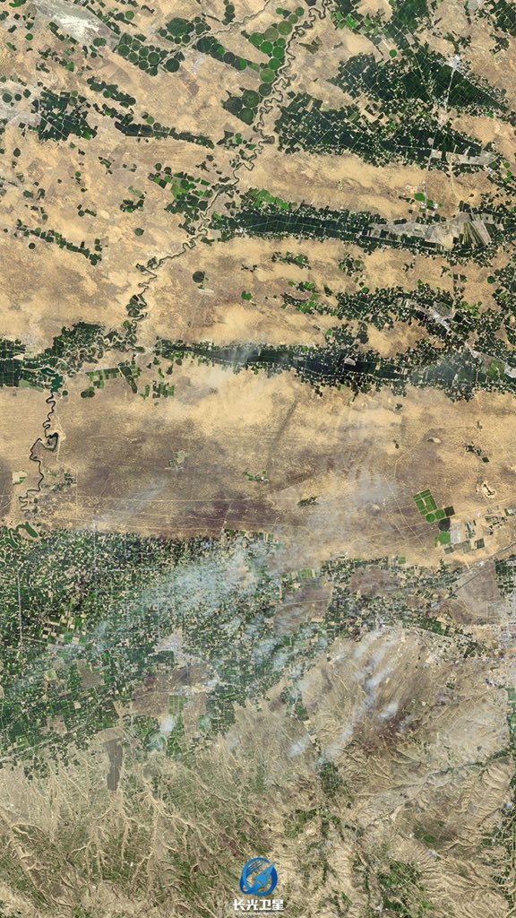
ムウス砂漠は中国北部の砂漠で、その南東端は万里の長城と交差しています。ムウス砂漠はオルドス砂漠の南部も形成しています。地域を流れる无定河(Wuding Rivdr)川は黄河に合流します。
地上の様子はこちらです。

参考文献: CNSA’s Tweet
地球俯瞰画像を見る: LiVEARTH
[Earthview Wonders] No.1685: Mu Us Desert (Maowusu Desert)🇨🇳
China’s Jilin 1 satellite captured the greening Mu Us Desert, China.
The Mu Us Desert (Maowusu Desert) is a desert in northern China. Its south-eastern end is crossed by the Great Wall of China. The Mu Us forms the southern portion of the Ordos Desert and part of the Ordos Loop. The Wuding River drains the area, and then flows into the Yellow River.
The local scenery on the ground is as follows.
Reference: CNSA’s Tweet
See earthview photo gallery: LiVEARTH[:en]【宇宙からの地球絶景】No.1685: 毛烏素沙漠(ムウス砂漠)🇨🇳
中国の地球観測衛星吉林一号が撮影した中国、内モンゴル自治区の毛烏素沙漠(ムウス砂漠)の緑化の様子です。
ムウス砂漠は中国北部の砂漠で、その南東端は万里の長城と交差しています。ムウス砂漠はオルドス砂漠の南部も形成しています。地域を流れる无定河(Wuding Rivdr)川は黄河に合流します。
地上の様子はこちらです。
https://upload.wikimedia.org/wikipedia/commons/b/be/1964-07_1964%E5%B9%B4_%E6%B2%BB%E7%90%86%E5%8D%81%E5%B9%B4%E5%90%8E%E7%9A%84%E9%99%95%E8%A5%BF%E6%AF%9B%E4%B9%8C%E8%8B%8F%E6%B2%99%E6%BC%A0.jpg
Credit: Wikipedia
参考文献: CNSA’s Tweet
地球俯瞰画像を見る: LiVEARTH
[Earthview Wonders] No.1685: Mu Us Desert (Maowusu Desert)🇨🇳
China’s Jilin 1 satellite captured the greening Mu Us Desert, China.
The Mu Us Desert (Maowusu Desert) is a desert in northern China. Its south-eastern end is crossed by the Great Wall of China. The Mu Us forms the southern portion of the Ordos Desert and part of the Ordos Loop. The Wuding River drains the area, and then flows into the Yellow River.
The local scenery on the ground is as follows.
Reference: CNSA’s Tweet
See earthview photo gallery: LiVEARTH[:]