[:ja]NASAの地球観測衛星Landsat 8が撮影したトルコのトゥズ湖です。
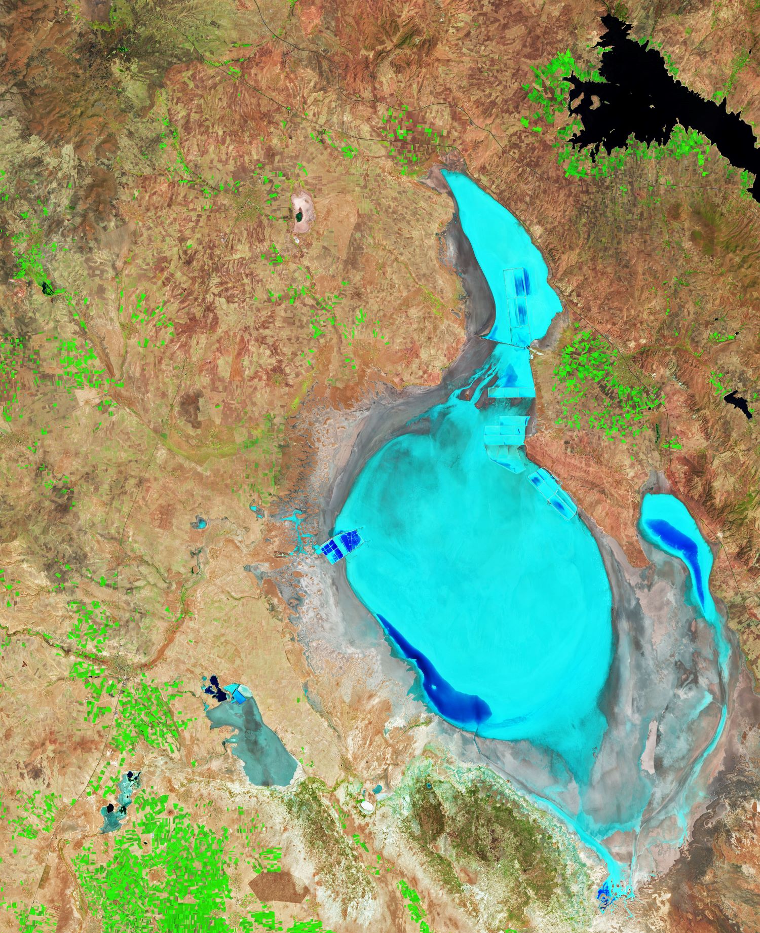
トゥズ湖は、アナトリア地方中央部に位置する深度1~2m、標高905mの塩湖で、トルコで2番目に大きい湖でしたが、2021年10月に完全に干上がりました。トルコの中央高原の地殻構造的くぼ地を占めるトゥズ湖は、地下水と地表水の2つの主要な水流によって水が供給されていますが、出口がありません。トゥズ湖は極端に塩分濃度が高く、夏の間は湖の水の多くが干上がり塩の層が表出する一方、冬には、塩が降雨と表流水によって湖にもたらされる真水に再び溶けます。この仕組みを利用して塩採取が行われており、トゥズ湖で稼働中の3つの採取場は、トルコで消費される塩の約70%を生産しています。また、2001年にトゥズ湖は、湖面すべてと周囲の水気の多い地層と隣接する一部の重要なステップ地域を含め、特別保護区に指定されました。湖南部にある群島は、オオフラミンゴのトルコ国内での主要繁殖地となっています。
地上の様子はこちらです。

参考文献: NASA Earth’s Tweet
地球俯瞰画像を見る: LiVEARTH
[Earthview Wonders] No.1706: Lake Tuz, Turkey🇹🇷
NASA’s Landsat 8 captured Lake Tuz, Turkey.
Lake Tuz in the Central Anatolia Region was the second largest lake in Turkey and one of the largest hypersaline lakes in the world. In recent years, Lake Tuz has become a hotspot for tourists. In October 2021, Lake Tuz dried up completely. The lake, occupying a tectonic depression in the central plateau of Turkey, is fed by two major streams, groundwater, and surface water, but has no outlet. During the summer the lake dries up exposing an average of 30cm thick salt layer, and this mechanism is used as a basis for the process of the salt mines in the lake.
The local scenery on the ground is as follows.
Reference: NASA Earth’s Tweet
See earthview photo gallery: LiVEARTH[:]