[:ja]NASAの観測衛星Terraが捉えた中国新疆ウイグル自治区のカシュガルです(フォールスカラー)。
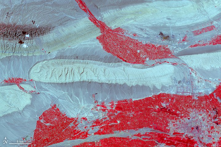
人口の80%はウイグル族など少数民族が占め、人口は120万人に達します。カシュガルは、古くからシルクロードの要衝として、またイスラームの拠点都市としても発展しました。タクラマカン砂漠西端に位置するオアシス都市で、天山山脈の麓に位置し、標高は1,200mです。
カシュガルの地上の様子はこちらです。

参考文献: Kashgar, China
ウェブ地球儀で地球俯瞰画像を見る: LiVEARTH
[Earthview Wonders] No.173: Kashgar
NASA’s Terra satellite captured Kashgar, Xinjiang Uyghur Autonomous Region, China (false color).
The city has 1.2 million population of which Muslim Uyghurs consists 80%. Kashgar had been the a pivotal trading point and Muslim city along the Silk Road. The oasis city is located at the western end of the Taklamakan Desert, at the foot of Tian Shan Mountains with 1,200m altitude.
The scenery of Kashgar on the ground is as follows.
Reference: Kashgar, China
See earthview photo gallery with web-globe: LiVEARTH[:en][Earthview Wonders] No.173: Kashgar
NASA’s Terra satellite captured Kashgar, Xinjiang Uyghur Autonomous Region, China (false color).
The city has 1.2 million population of which Muslim Uyghurs consists 80%. Kashgar had been the a pivotal trading point and Muslim city along the Silk Road. The oasis city is located at the western end of the Taklamakan Desert, at the foot of Tian Shan Mountains with 1,200m altitude.
The scenery of Kashgar on the ground is as follows.
Reference: Kashgar, China
See earthview photo gallery with web-globe: LiVEARTH[:]