[:ja]大西宇宙飛行士がISSから撮影したスペイン🇪🇸、イベリア半島です。Google Earthで見るとこのような向きですね。地球の弧と一緒に見ると、如何に平面の地図が不自然なものか、気づかされます。
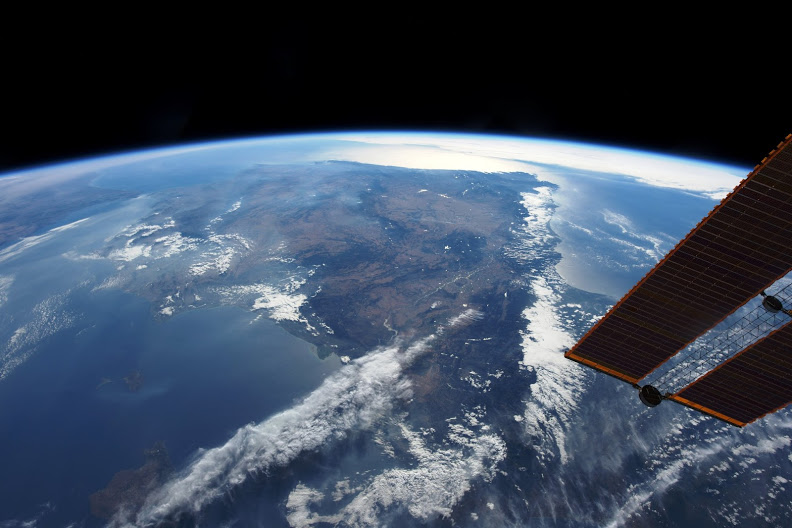
手前にはピレネー山脈とアンドラ公国が、また、奥には、ジブラルタル海峡と、モロッコのタンジェが見えています。
こちらは地上のイベリア半島、アンダルシア地方の景色です。

参考文献: Takuya Onishi’s Post
ウェブ地球儀で地球俯瞰画像を見る: LiVEARTH
[Earthview Wonders] No.179: Spain🇪🇸
Astronaut Takuya Onishi captured Spain🇪🇸, Iberian Peninsula. Using Google Earth, the scenery is taken from this angle. Looking at the real land with the arc of Earth, flat map seems to be unnatural.
At the near side lies Pyrenees and Andorra, and at the far side lies Gibraltar Strait and Tanger of Morocco.
This is the scenery of the Iberian Peninsula on the ground.
Reference: Takuya Onishi’s Post
See earthview photo gallery with web-globe: LiVEARTH
[:en][Earthview Wonders] No.179: Spain🇪🇸
Astronaut Takuya Onishi captured Spain🇪🇸, Iberian Peninsula. Using Google Earth, the scenery is taken from this angle. Looking at the real land with the arc of Earth, flat map seems to be unnatural.
At the near side lies Pyrenees and Andorra, and at the far side lies Gibraltar Strait and Tanger of Morocco.
This is the scenery of the Iberian Peninsula on the ground.
Reference: Takuya Onishi’s Post
See earthview photo gallery with web-globe: LiVEARTH
[:]