[:ja]国際宇宙ステーションISSから撮影された、ペルーとボリビアのチチカカ湖のサングリント(sunglint)です。サングリントとは、太陽光が水面に対し観察者とほぼ同じ角度に反射する鏡面反射のことで、湖面のさざなみがはっきりと確認できるほどです。
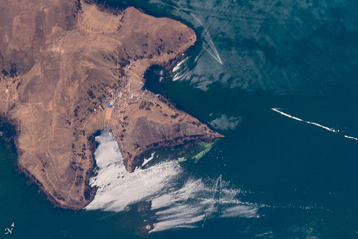
ちなみに、チチカカ湖はアンデス山中のペルー南部とボリビア西部にまたがる南米最大の淡水湖で、標高は3,812mです。湖面の60%がペルー領で40%がボリビア領です。湖には41の大小の島々があり、ペルー側にあるプーノ市街の沿岸や沖合にはウル族がトトラと呼ばれる葦を多数重ね合わせた浮島に居住しています。
地上の様子はこちらです。

参考文献: Sunglint on Lake Titicaca
ウェブ地球儀で地球俯瞰画像を見る: LiVEARTH
[Earthview Wonders] No.243: Sunglint on Lake Titicaca🇵🇪🇧🇴
International Space Station (ISS) captured the sunglint of Lake Titicaca that belongs to Peru and Bolivia. Sunglint is a phenomenon that occurs when sunlight reflects off the surface of the ocean at the same angle that a satellite is viewing the surface.
Lake Titicaca with a surface elevation of 3,812m is in the Andes on the border of Bolivia and Peru, and is the largest lake in South America. The lake as 41 islands, and Uros (or Uru) people form layers of cut totora, a thick buoyant reed that grows abundantly in the shallows of the lake.
The local scenery on the ground is as follows.
Reference: Sunglint on Lake Titicaca
See earthview photo gallery with web-globe: LiVEARTH[:en][Earthview Wonders] No.243: Sunglint on Lake Titicaca🇵🇪🇧🇴
International Space Station (ISS) captured the sunglint of Lake Titicaca that belongs to Peru and Bolivia. Sunglint is a phenomenon that occurs when sunlight reflects off the surface of the ocean at the same angle that a satellite is viewing the surface.
Lake Titicaca with a surface elevation of 3,812m is in the Andes on the border of Bolivia and Peru, and is the largest lake in South America. The lake as 41 islands, and Uros (or Uru) people form layers of cut totora, a thick buoyant reed that grows abundantly in the shallows of the lake.
The local scenery on the ground is as follows.
Reference: Sunglint on Lake Titicaca
See earthview photo gallery with web-globe: LiVEARTH[:]