[:ja]国際宇宙ステーションISSから撮影されたオーストラリアのエーア湖(カティサンダ)です。面積約9,400km2、海面下約15mのエーア湖は南オーストラリア州北部のオーストラリア最大の湖です。
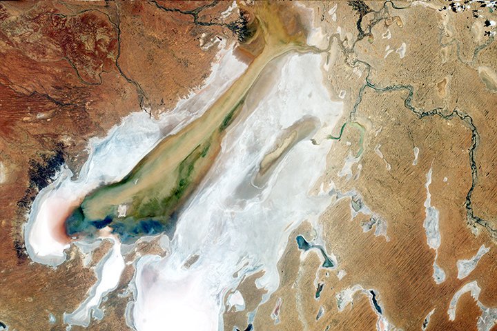
湖水の多くは、クイーンズランド州のアウトバック(未開拓奥地)である北西から流れて来ますが、エーア湖盆地がほとんど平らであるため、水量は途中で減少します。その時期の降水量によって異なり、乾季にはほぼ完全に干上がることもありますが、数年毎に起こる洪水の時期には、短期間で多彩な生命活動が営まれます。衛星画像では、2016年の大雨の影響で起きた洪水のため植生が繁茂し、左方の緑色はこれを示しています。
地上の様子はこちらです。

参考文献: Flood Waters Reach Kati Thanda–Lake Eyre
ウェブ地球儀で地球俯瞰画像を見る: LiVEARTH
[Earthview Wonders] No.250: Lake Eyre of Australia🇦🇺
International Space Station (ISS) captured Lake Eyre (Kati Thanda) of Australia. The lake has 9,400km2 area and is at 15m below sea lavel and is the largest of Australia.
During the rainy season the rivers from the north-east part of the Lake Eyre Basin (in outback (south-west and central) Queensland) flow towards the lake while during the dry season the lake occasionally dries up. With abundant water after a heavy rainfall, life flourishes. This satellite image shows that 2016 heavy rain and flood gave rise to a variety of colors indicating new vegetation, algae-tinted water, and uds transported by the flood water.
The local scenery on the ground is as follows.
Reference: Flood Waters Reach Kati Thanda–Lake Eyre
See earthview photo gallery with web-globe: LiVEARTH[:en][Earthview Wonders] No.250: Lake Eyre of Australia🇦🇺
International Space Station (ISS) captured Lake Eyre (Kati Thanda) of Australia. The lake has 9,400km2 area and is at 15m below sea lavel and is the largest of Australia.
During the rainy season the rivers from the north-east part of the Lake Eyre Basin (in outback (south-west and central) Queensland) flow towards the lake while during the dry season the lake occasionally dries up. With abundant water after a heavy rainfall, life flourishes. This satellite image shows that 2016 heavy rain and flood gave rise to a variety of colors indicating new vegetation, algae-tinted water, and uds transported by the flood water.
The local scenery on the ground is as follows.
Reference: Flood Waters Reach Kati Thanda–Lake Eyre
See earthview photo gallery with web-globe: LiVEARTH[:]