[:ja]NASAの地球観測衛星Aquaが捉えた、バレンツ海のクラウドストリートです。クラウドストリートは、積雲がストリート(道)のように連なって現れる現象で、バレンツ海では冬の終わり頃に頻繁に見られます。
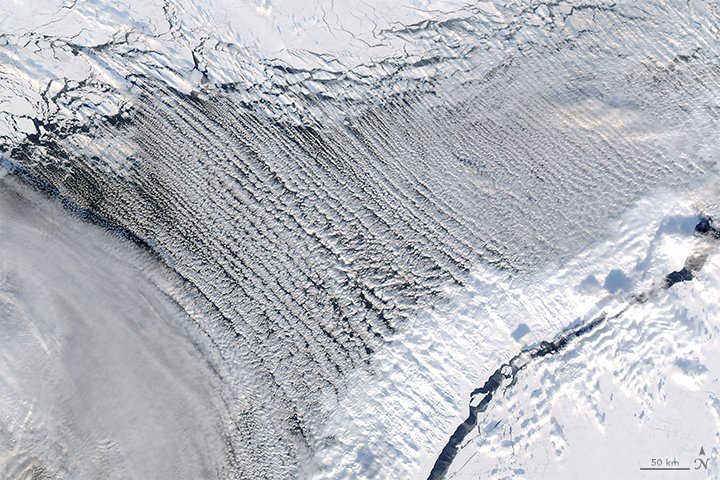
大陸からの氷や雪を運ぶ風が、海からの湿った空気にぶつかり、温かい空気が上空にある場合、水蒸気がその下に捉えられます。そして地面と平行に置かれた円柱のように渦を巻いた空気のかたまりがいくつも発生し、道のように連なった積雲が形成されます。
地上の様子はこちらです。

参考文献: Traffic-free and Sky-high
ウェブ地球儀で地球俯瞰画像を見る: LiVEARTH
[Earthview Wonders] No.252: Cloud Streets of Barents Sea
NASA’s Aqua satellite captured the “Cloud Streets” of Barents Sea. Cloud Streets feature trailing parallel bands of water vapor and such formations occur frequently in the region in late winter.
Cloud streets form when moisture rises from warmer water (compared to the air just above) in columns of heated air called thermals. These thermals rise until they are trapped under a layer of warmer air in a process called temperature inversion. This makes cylinders of rotating air that cool and condense into cumulus clouds.
The clouds look like this near the ground.
Reference: Traffic-free and Sky-high
See earthview photo gallery with web-globe: LiVEARTH[:en][Earthview Wonders] No.252: Cloud Streets of Barents Sea
NASA’s Aqua satellite captured the “Cloud Streets” of Barents Sea. Cloud Streets feature trailing parallel bands of water vapor and such formations occur frequently in the region in late winter.
Cloud streets form when moisture rises from warmer water (compared to the air just above) in columns of heated air called thermals. These thermals rise until they are trapped under a layer of warmer air in a process called temperature inversion. This makes cylinders of rotating air that cool and condense into cumulus clouds.
The clouds look like this near the ground.
Reference: Traffic-free and Sky-high
See earthview photo gallery with web-globe: LiVEARTH[:]