[:ja]欧州宇宙機関ESAの地球観測衛星Sentinel-2Bが撮影した世界最大の塩湖、ボリビアのウユニ塩原(湖)です。
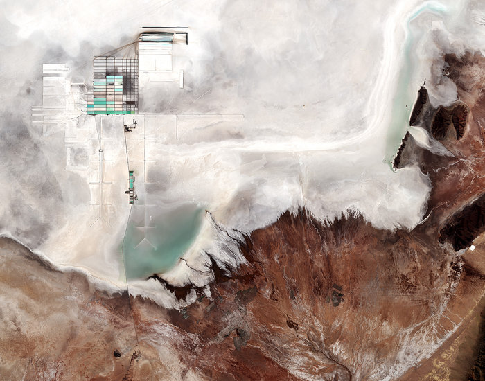
ウユニ塩原はボリビア中央西部のアルティプラーノにある塩の大地で、標高約3,700mにある南北約100km、東西約250km、面積約10,582km2の広大な塩の固まりです。この塩原は高低差が100km四方で50cmしかないことが調査により判明しており、「世界で最も平らな場所」でもあります。そのため雨季に雨により冠水すると、その水が波も立たないほど薄く広がるため、水が蒸発するまでのわずかな期間に「天空の鏡」と形容される巨大な鏡が出現します。
画像左上の幾何学模様は、国営のリチウム生産工場で、塩水からリチウム炭酸塩が分離されます。
地上の様子はこちらです。

参考文献: Uyuni Salt Flat, Bolivia (ESA Space in Images)
ウェブ地球儀で地球俯瞰画像を見る: LiVEARTH
[Earthview Wonders] No.290: Uyuni Salt Flat🇧🇴
ESA’s Sentinel-2B satellite captured Uyuni Salt Flat (Salar de Uyuni) of Bolivia, the largest salt flat in the world.
Occupying over 10,000km2, the vast Salar de Uyuni lies at the southern end of the Altiplano, a high plain of inland drainage in the central Andes. On the whole, the Salar de Uyuni is very flat, with a surface elevation variation of less than 1m.
The geometric shapes in the upper left are large evaporation ponds of the national lithium plant, where lithium bicarbonate is isolated from salt brine.
The local scenery on the ground is as follows.
Reference: Uyuni Salt Flat, Bolivia (ESA Space in Images)
See earthview photo gallery with web-globe: LiVEARTH[:en][Earthview Wonders] No.290: Uyuni Salt Flat🇧🇴
ESA’s Sentinel-2B satellite captured Uyuni Salt Flat (Salar de Uyuni) of Bolivia, the largest salt flat in the world.
Occupying over 10,000km2, the vast Salar de Uyuni lies at the southern end of the Altiplano, a high plain of inland drainage in the central Andes. On the whole, the Salar de Uyuni is very flat, with a surface elevation variation of less than 1m.
The geometric shapes in the upper left are large evaporation ponds of the national lithium plant, where lithium bicarbonate is isolated from salt brine.
The local scenery on the ground is as follows.
Reference: Uyuni Salt Flat, Bolivia (ESA Space in Images)
See earthview photo gallery with web-globe: LiVEARTH[:]