[:ja]欧州宇宙機関ESAの地球観測衛星Sentinel-3Aが撮影したロシアのカムチャッカ半島です。オホーツク海上の白色の雲は氷や雪と混ざっています。
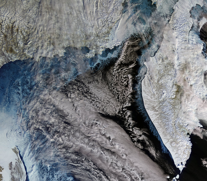
ロシアのシベリアにあるカムチャッカ半島は、環太平洋火山帯に沿っており、29の活火山を含む160の火山で覆われています。半島最高峰のクリュチェフスカヤ山(4,835m)はここ300年で50回もの大爆発をしていますが、多くの火山を抱えています。
カムチャッカ半島の地上の様子はこちらです。

参考文献: Earth From Space (ESA)
ウェブ地球儀で地球俯瞰画像を見る: LiVEARTH
[Earthview Wonders] No.398: Kamchatka Peninsula, Russia🇷🇺
ESA’s Sentinel-3A satellite captured the Sea of Okhotsk and the Kamchatka Peninsula in the Russian Far East, where clouds blend with the ice and snow.
Located in the Russian Far East, this peninsula has a landscape covered with volcanoes due to its location along the highly active Pacific ‘Ring of Fire’. There are about 160 volcanoes on the peninsula, 29 of which are still active. The highest volcano is Klyuchevskaya Sopka (4,835m), which erupted 50 timed in the past 300 years.
Local scenery on the ground is as follows.
Reference: Earth From Space (ESA)
See earthview photo gallery with web-globe: LiVEARTH[:en][Earthview Wonders] No.398: Kamchatka Peninsula, Russia🇷🇺
ESA’s Sentinel-3A satellite captured the Sea of Okhotsk and the Kamchatka Peninsula in the Russian Far East, where clouds blend with the ice and snow.
Located in the Russian Far East, this peninsula has a landscape covered with volcanoes due to its location along the highly active Pacific ‘Ring of Fire’. There are about 160 volcanoes on the peninsula, 29 of which are still active. The highest volcano is Klyuchevskaya Sopka (4,835m), which erupted 50 timed in the past 300 years.
Local scenery on the ground is as follows.
Reference: Earth From Space (ESA)
See earthview photo gallery with web-globe: LiVEARTH[:]