[:ja]欧州宇宙機関ESAの地球観測衛星Sentinel-2Aが撮影したブラジル北東のマラジョ島(フォールスカラー)です。
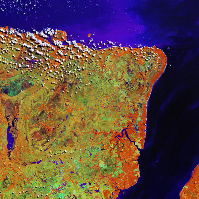
画像は強調したい部分を際立たせるためにフォールスカラーになっていますが、画像上方の青色は、アマゾン川河口付近に流された堆積物です。この地域はサバンナ気候ですが、大西洋近くのアマゾン川沿岸にはマングローブやヤシが群生しており、ファゼンダと呼ばれる大規模プランテーションも多くあります。これらの植生から放出された水蒸気から、雲が形成されています。
地上の様子はこちらです。

参考文献: Marajó, Brazil
ウェブ地球儀で地球俯瞰画像を見る: LiVEARTH
[Earthview Wonders] No.440: Marajó, Brazil🇧🇷
ESA’s Sentinel-2A satellite captured northern Brazil’s Marajó island.
In this false color image, sediments discharged by the nearby Amazon River mouth are visible as blue in the waters of the Atlantic Ocean north of the island. The area is dominated by a savannah landscape with large plantations called fazendas, and also with mangrove forests and palm swamps along the coast. ‘Popcorn’ clouds are visible in the upper part of the image, formed by convection and condensed water vapor released by plants.
The local scenery on the ground is as follows.
Reference: Marajó, Brazil
See earthview photo gallery with web-globe: LiVEARTH[:en][Earthview Wonders] No.440: Marajó, Brazil🇧🇷
ESA’s Sentinel-2A satellite captured northern Brazil’s Marajó island.
In this false color image, sediments discharged by the nearby Amazon River mouth are visible as blue in the waters of the Atlantic Ocean north of the island. The area is dominated by a savannah landscape with large plantations called fazendas, and also with mangrove forests and palm swamps along the coast. ‘Popcorn’ clouds are visible in the upper part of the image, formed by convection and condensed water vapor released by plants.
The local scenery on the ground is as follows.
Reference: Marajó, Brazil
See earthview photo gallery with web-globe: LiVEARTH[:]