[:ja]NASAの地球観測衛星Terraが撮影したカナダ、ニューファンドランド・ラブラドール州東岸の地表、海氷、雲の3重層です。
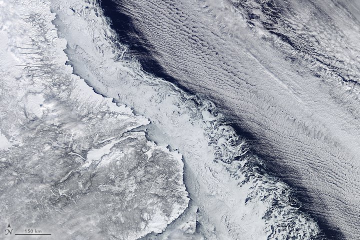
地表と海氷の沿岸は明確ですが、海氷の東端は渦を巻いており、これは海氷が形成されつつあり、固まっていないために、海流や風などで流されています。その東のクラウドストリート(積雲が道のように連なっている様子)は、西の暖かい地表から海に向かって吹く西風によるものです。海氷とのギャップがあるのは、西風が水蒸気を吸収している場所で、十分に吸収したな水分が冷やされて雲が形成されています。
地上付近からの流氷の様子はこちらです。

参考文献: An Intersection of Land, Ice, Sea, and Clouds
ウェブ地球儀で地球俯瞰画像を見る: LiVEARTH
[Earthview Wonders] No.483: 3 Layer Image of Canadian Coast🇨🇦
NASA’s Terra satellite captured this 3 layer image of coastline, sea ice and clouds off of Newfoundland and Labrador Province, Canada.
In this image, the coastline, the sea ice edge, and offshore clouds all present a clear edge to distinguish one from the next. The swirl patterns on the eastern edge of the sea ice reveal areas where ice is new and has not yet consolidated into a solid sheet, susceptible to stirring by winds and by ocean currents. The cloud streets to the right indicate strong and cold winds were blowing from west to east from the interior of Labrador. The gap between the ice and the cloud streets occurs because the cold winds need some “fetch” (a distance of open water) to pick up moisture for cloud formation.
This is the closer image of the sea ice swirls in the Labrador Current captured from a trans-Atlantic flight. (Image: Courtesy Daniel Schwen)
Reference: An Intersection of Land, Ice, Sea, and Clouds
See earthview photo gallery with web-globe: LiVEARTH[:en][Earthview Wonders] No.483: 3 Layer Image of Canadian Coast🇨🇦
NASA’s Terra satellite captured this 3 layer image of coastline, sea ice and clouds off of Newfoundland and Labrador Province, Canada.
In this image, the coastline, the sea ice edge, and offshore clouds all present a clear edge to distinguish one from the next. The swirl patterns on the eastern edge of the sea ice reveal areas where ice is new and has not yet consolidated into a solid sheet, susceptible to stirring by winds and by ocean currents. The cloud streets to the right indicate strong and cold winds were blowing from west to east from the interior of Labrador. The gap between the ice and the cloud streets occurs because the cold winds need some “fetch” (a distance of open water) to pick up moisture for cloud formation.
This is the closer image of the sea ice swirls in the Labrador Current captured from a trans-Atlantic flight. (Image: Courtesy Daniel Schwen)
Reference: An Intersection of Land, Ice, Sea, and Clouds
See earthview photo gallery with web-globe: LiVEARTH[:]