[:ja]国際宇宙ステーションISSから撮影されたドーバー海峡です。ドーバー海峡は、イギリスとフランスを隔てる海峡の最狭部で、フランス語ではカレー海峡(Pas de Calais)と呼ばれます。
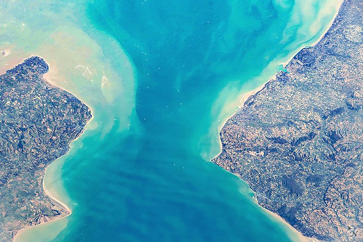
海峡の両側の英仏とも海底含め同じ岩石であるチョークで出来ており、海峡になる前の氷河期には地続きであったと考えられています。直線距離34kmというきわめて狭い海峡であるがゆえに遠泳のコースとしても有名であり、昔から世界中のスイマーの憧れの海となってきました。南西から北東へ流れる潮流が速く実際に泳ぐ距離は約50~60km程度とされ、冷たい水温、夜を徹して泳ぐことになる精神的疲労などのさまざまな障害があり、単独横断泳の成功率は現在でも60%程度です。
地上の様子はこちらです。

参考文献: Strait of Dover’s Tweet
ウェブ地球儀で地球俯瞰画像を見る: LiVEARTH
[Earthview Wonders] No.530: Strait of Dover🇬🇧🇫🇷
International Space Station ISS captured the Strait of Dover (Pas de Calais) which separates UK and France.
This 34km strait is believed to have been created by the erosion of a chalk land bridge. The erosion of both coasts has created the famous white cliffs of Dover in the UK and the Cap Blanc Nez in France. Over the years, adventurous swimmers have attempted to swim the strait. Swimmers commonly follow a curved path due to tidal currents, making the actual route longer than the projected straight-line distance between the coasts, spending 7 to 20 hours to complete one-way. Few have chosen to swim back.
The local scenery on the ground is as follows.
Reference: Strait of Dover’s Tweet
See earthview photo gallery with web-globe: LiVEARTH[:en][Earthview Wonders] No.530: Strait of Dover🇬🇧🇫🇷
International Space Station ISS captured the Strait of Dover (Pas de Calais) which separates UK and France.
This 34km strait is believed to have been created by the erosion of a chalk land bridge. The erosion of both coasts has created the famous white cliffs of Dover in the UK and the Cap Blanc Nez in France. Over the years, adventurous swimmers have attempted to swim the strait. Swimmers commonly follow a curved path due to tidal currents, making the actual route longer than the projected straight-line distance between the coasts, spending 7 to 20 hours to complete one-way. Few have chosen to swim back.
The local scenery on the ground is as follows.
Reference: Strait of Dover’s Tweet
See earthview photo gallery with web-globe: LiVEARTH[:]