[:ja]米国のLandsat8がISSから撮影した北極圏にあるノルウェー領の群島、スヴァールバル諸島です。
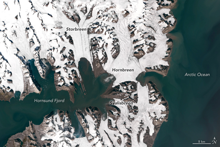
スヴァールバル諸島は北極海のヨーロッパ寄りに位置し、東はバレンツ海、西にあるグリーンランドとの間はフラム海峡、南西はグリーンランド海、南東はノルウェー海に囲まれています。唯一の有人島であるスピッツベルゲン島をはじめとするほぼ不毛の島々からなります。島の約6割が大小無数の氷河に覆われており、氷河以外の大地はほとんどが永久凍土なので、植生が見られるのは6.7%に過ぎない。温暖化の影響により、1970年と比べると、ストルブリーン氷河2017年の氷河は数kmと大きく後退しています。
地上の様子はこちらです。

参考文献: Losing Ice in Svalbard
ウェブ地球儀で地球俯瞰画像を見る: LiVEARTH[:en][Earthview Wonders] No.535: Losing Ice in Svalbards🇳🇴
Landsat 8 captured from ISS Svalbard Island, Norwegian archipelago in the Arctic Ocean.
Glacial ice covers 60% of Svalbard; 30% is barren rock while only 10% is vegetated. The landforms of Svalbard were created through repeated ice ages, when glaciers cut the former plateau into fjords, valleys and mountains. Many of the glaciers have seen their termini retreat by several kilometers. One of the largest and fastest changing was Storbreen. In Storbreen’s case, in 1990, 2013, and 2015, the snow line left only 20% of the glacier in the accumulation zone.
The local scenery on the ground is as follows.
Reference: Losing Ice in Svalbard
See earthview photo gallery with web-globe: LiVEARTH
[Earthview Wonders] No.535: Losing Ice in Svalbards🇳🇴
Landsat 8 captured from ISS Svalbard Island, Norwegian archipelago in the Arctic Ocean.
Glacial ice covers 60% of Svalbard; 30% is barren rock while only 10% is vegetated. The landforms of Svalbard were created through repeated ice ages, when glaciers cut the former plateau into fjords, valleys and mountains. Many of the glaciers have seen their termini retreat by several kilometers. One of the largest and fastest changing was Storbreen. In Storbreen’s case, in 1990, 2013, and 2015, the snow line left only 20% of the glacier in the accumulation zone.
The local scenery on the ground is as follows.
Reference: Losing Ice in Svalbard
See earthview photo gallery with web-globe: LiVEARTH[:]