[:ja]リッキー・アーノルド宇宙飛行士がISSから撮影したカザフスタンとウズベキスタンにまたがる塩湖のアラル海です。
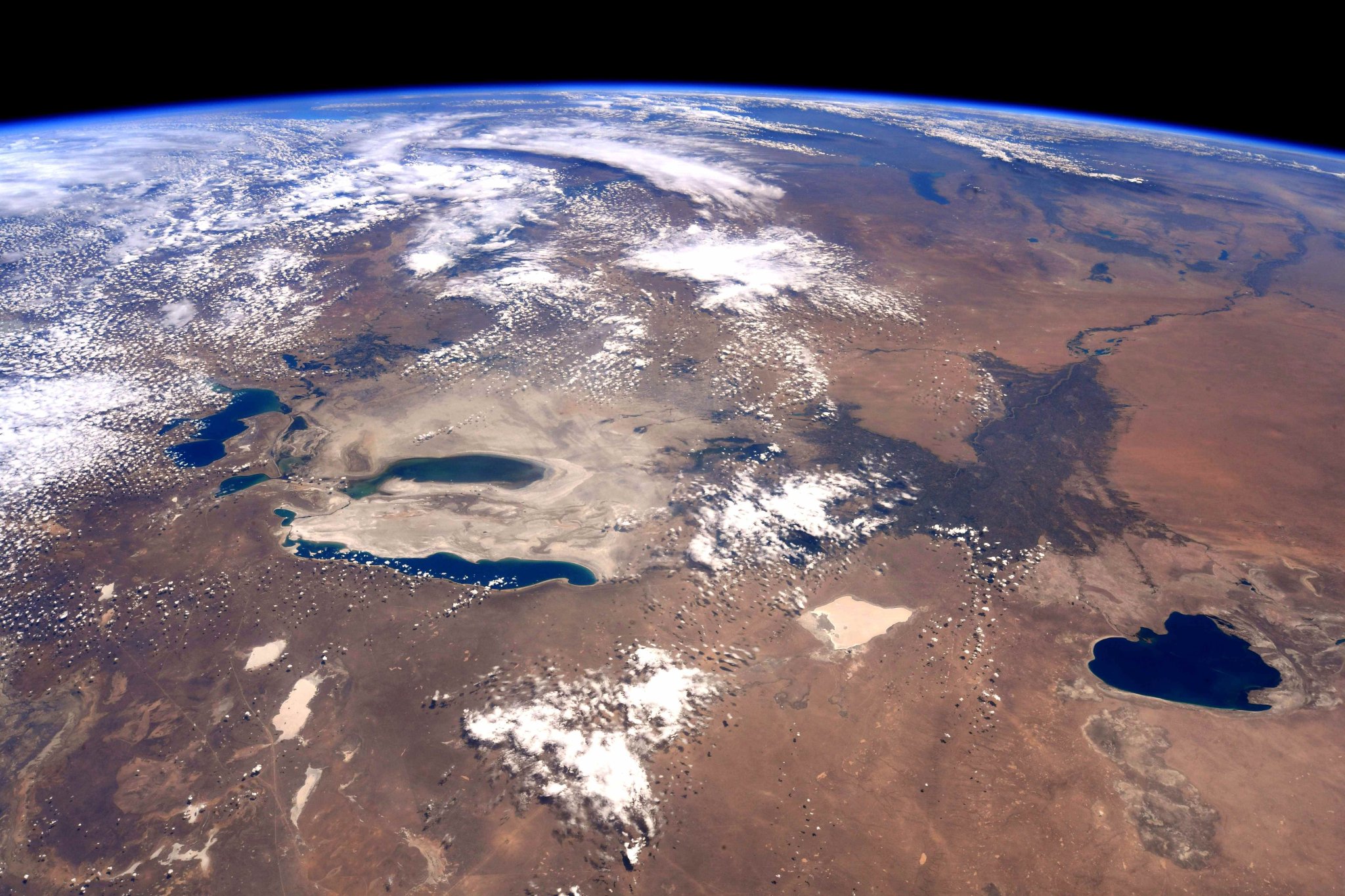
アラル海は中央アジア西部の内陸湖です。アラル海は1960年代までは日本の東北地方とほぼ同じ大きさの湖沼面積を誇る世界第4位の湖でしたが、半世紀で約5分の1に縮小しました。旧ソ連が60年代に乾燥地域の同地域を耕作地に変える計画の中で、大量の農業用水を確保するために水を利用したのが主な原因と考えられています。既に干上がった部分はアラルクム砂漠と呼ばれます。また、これら人的要因による湖の縮小とそれにともなう周辺環境の急変は、「20世紀最大の環境破壊」とも言われています。
1989年と2014年の比較画像はこちらです。
また、地上の様子はこちらです。

ここに行ってみる! (Credit: Kovács Tibor)
参考文献: Ricky Arnold’s Tweet
ウェブ地球儀で地球俯瞰画像を見る: LiVEARTH
[Earthview Wonders] No.545: Aral Sea🇰🇿🇺🇿
Astronaut Ricky Arnold captured from ISS the Aral Sea between Kazakhstan and Uzbekistan.
Formerly one of the four largest lakes in the world, the Aral Sea has been shrinking since at least 1850 and the shrinking has accelerated since the 1960s after the rivers that fed it were diverted by Soviet irrigation projects. Satellite images taken by NASA in August 2014 revealed that for the first time in modern history the eastern basin of the Aral Sea had completely dried up. The eastern basin is now called the Aralkum Desert. UNESCO added the historical documents concerning the development of the Aral Sea to its Memory of the World Register as a unique resource to study this “environmental tragedy”.
Comparison of the Aral Sea in 1989 and 2014 is as follows.
Credit: Wikipedia
The local scenery on the ground is as follows.
I want to be there! (Credit: Kovács Tibor)
Reference: Ricky Arnold’s Tweet
See earthview photo gallery with web-globe: LiVEARTH[:en][Earthview Wonders] No.545: Aral Sea🇰🇿🇺🇿
Astronaut Ricky Arnold captured from ISS the Aral Sea between Kazakhstan and Uzbekistan.
Formerly one of the four largest lakes in the world, the Aral Sea has been shrinking since at least 1850 and the shrinking has accelerated since the 1960s after the rivers that fed it were diverted by Soviet irrigation projects. Satellite images taken by NASA in August 2014 revealed that for the first time in modern history the eastern basin of the Aral Sea had completely dried up. The eastern basin is now called the Aralkum Desert. UNESCO added the historical documents concerning the development of the Aral Sea to its Memory of the World Register as a unique resource to study this “environmental tragedy”.
Comparison of the Aral Sea in 1989 and 2014 is as follows.
Credit: Wikipedia
The local scenery on the ground is as follows.
I want to be there! (Credit: Kovács Tibor)
Reference: Ricky Arnold’s Tweet
See earthview photo gallery with web-globe: LiVEARTH[:]