[:ja]地球観測衛星Landsat 8が撮影したカナダ、ケベック州のジェームス湾(南東部分はルパート湾)です。画像では、南東のルベール川などからの堆積物がジェームス湾の塩水と交わる様子が見られます。
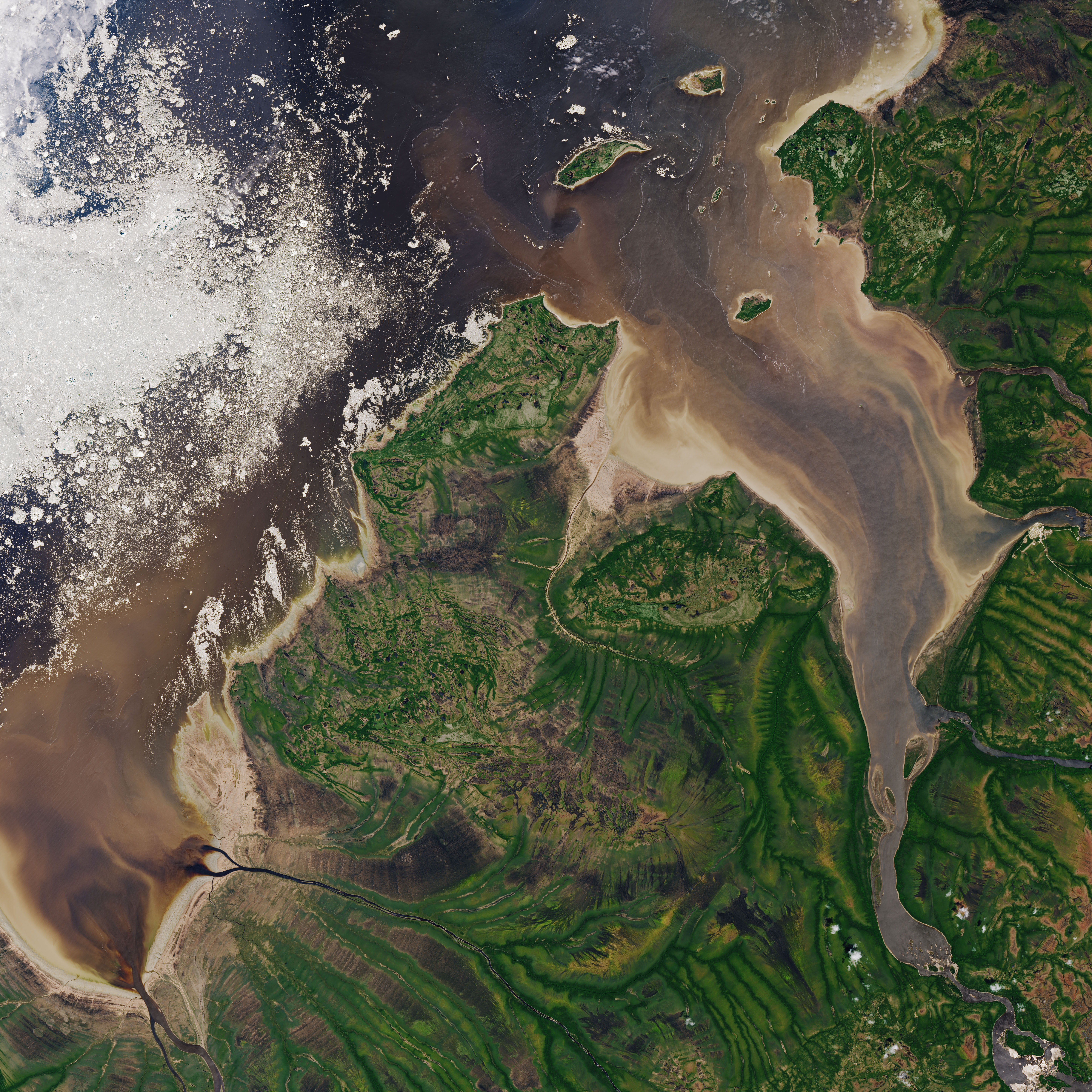
ジェームス湾はハドソン湾の南方にある南北に細長い湾で、カナダのケベック州とオンタリオ州に挟まれており、北のハドソン湾に向けて湾口を開いています。なお、湾内のアキミスキ島などの島はヌナブト準州の所属となっています。
地上の様子はこちらです。

参考文献: Filaments and Color in Rupert Bay (NASA Earth Observatory)
地球俯瞰画像を見る: LiVEARTH
[Earthview Wonders] No.601: James Bay, Canada🇨🇦
NASA’s Landsat 8 captured James Bay (Rupert Bay in the southeast), Quebec, Canada. The image shows the the estuary or the mouth of Rupert River at James Bay where fresh river water meets sea water.
Rupert Bay is a large arm of Jamaes Bay located on the south-east shore, which is also a part of Hudson Bay in Canada. Although the coast is part of the province of Quebec, the waters of the bay are under jurisdiction of Nunavut Territory. This bay has a width of 16km and a length of 32km. The Rupert, Nottaway and Broadback Rivers empty into this bay. The image also shows interesting element—long, white, meandering filaments of foam which could be a signature of the boundary between continental fresh water and salty marine water.
The local scenery on the ground is as follows.
Reference: Filaments and Color in Rupert Bay (NASA Earth Observatory)
See earthview photo gallery: LiVEARTH[:en][Earthview Wonders] No.601: James Bay, Canada🇨🇦
NASA’s Landsat 8 captured James Bay (Rupert Bay in the southeast), Quebec, Canada. The image shows the the estuary or the mouth of Rupert River at James Bay where fresh river water meets sea water.
Rupert Bay is a large arm of Jamaes Bay located on the south-east shore, which is also a part of Hudson Bay in Canada. Although the coast is part of the province of Quebec, the waters of the bay are under jurisdiction of Nunavut Territory. This bay has a width of 16km and a length of 32km. The Rupert, Nottaway and Broadback Rivers empty into this bay. The image also shows interesting element—long, white, meandering filaments of foam which could be a signature of the boundary between continental fresh water and salty marine water.
The local scenery on the ground is as follows.
Reference: Filaments and Color in Rupert Bay (NASA Earth Observatory)
See earthview photo gallery: LiVEARTH[:]