[:ja]アレックス・ゲルスト宇宙飛行士がISSから撮影した千島列島(クリル諸島)とカルマン渦です。
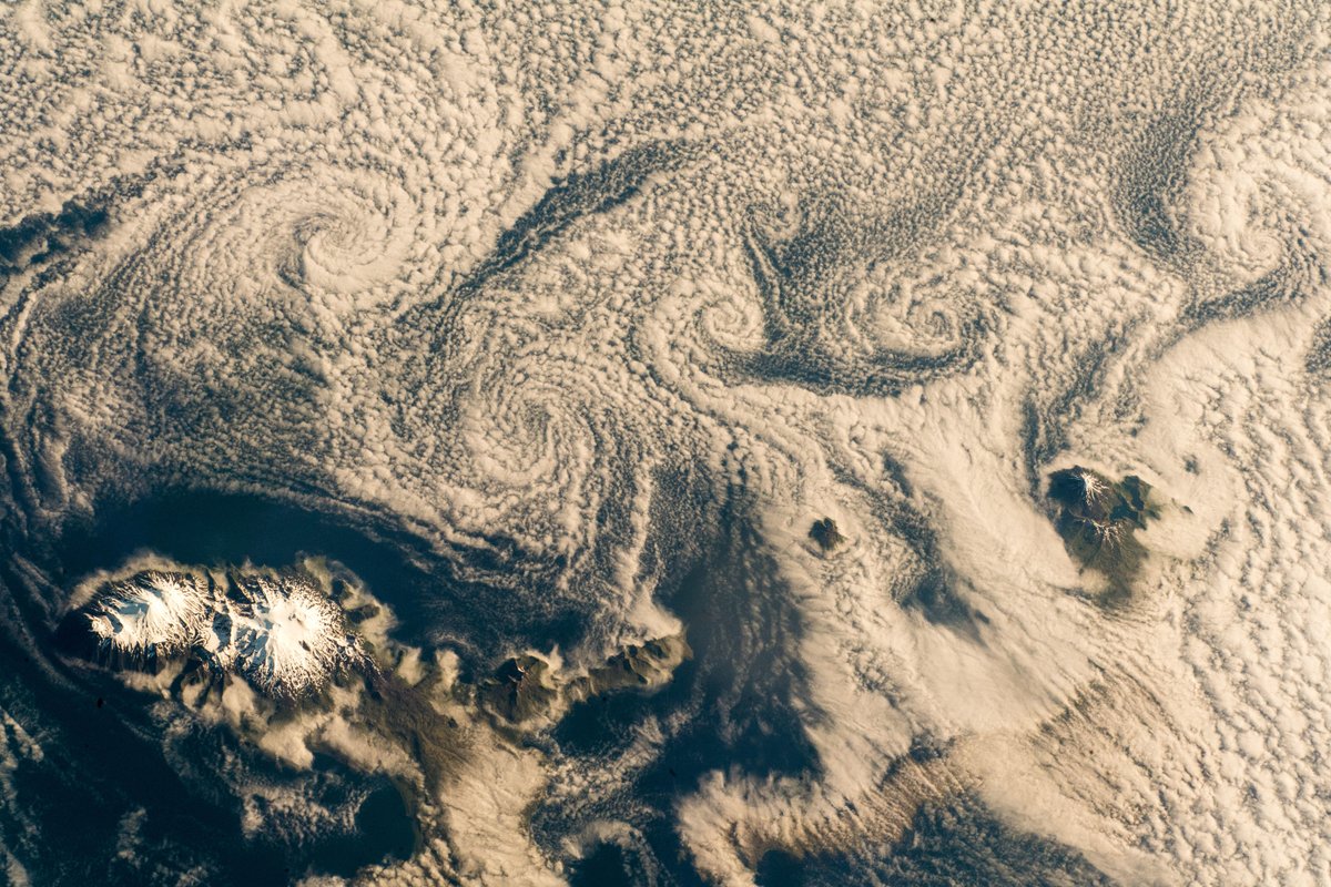
千島列島(ロシア:クリル諸島)は、北海道からカムチャツカ半島まで連なる列島です。環太平洋火山帯の一部をなす火山列島であり、北アメリカプレートの下に太平洋プレートがもぐりこんだ結果生じた成層火山の頂上にあたり、今でも多くの島が活発に火山活動を起こしています。画像中の雲のカルマン渦は、流れのなかに置かれた障害物を動かした時、その後方に交互にできる渦の列のことで、自然現象では、この画像のように、島の風下側に雲渦が形成されることがあります。
千島列島の地上の様子はこちらです。

参考文献: Alex Gerst’s Tweet
地球俯瞰画像を見る: LiVEARTH
[Earthview Wonders] No.620: Kuril Islands (Chishima Islands) and Karman Vortices🇷🇺
Astronaut Alex Gerst captured from ISS Kuril Islands (Chishima Islands in Japanese).
The Kuril Islands are a volcanic archipelago, a part of the Ring of Fire, formed as a result of the subduction of the Pacific Plate under the Okhotsk Plate. The islands stretch northeast from Hokkaido, Japan, to Kamchatka, Russia, separating the Sea of Okhotsk from the north Pacific Ocean. The chain has around 100 volcanoes, some 40 of which are active, and many hot springs and fumaroles, and there is frequent seismic activity. Also, as shown in the image, the flow of atmospheric air over obstacles such as islands or isolated mountains sometimes gives birth to von Kármán vortex streets. When a cloud layer is present at the relevant altitude, the streets become visible.
The local scenery on the ground is as follows.
Reference: Alex Gerst’s Tweet
See earthview photo gallery: LiVEARTH[:en][Earthview Wonders] No.620: Kuril Islands (Chishima Islands) and Karman Vortices🇷🇺
Astronaut Alex Gerst captured from ISS Kuril Islands (Chishima Islands in Japanese).
The Kuril Islands are a volcanic archipelago, a part of the Ring of Fire, formed as a result of the subduction of the Pacific Plate under the Okhotsk Plate. The islands stretch northeast from Hokkaido, Japan, to Kamchatka, Russia, separating the Sea of Okhotsk from the north Pacific Ocean. The chain has around 100 volcanoes, some 40 of which are active, and many hot springs and fumaroles, and there is frequent seismic activity. Also, as shown in the image, the flow of atmospheric air over obstacles such as islands or isolated mountains sometimes gives birth to von Kármán vortex streets. When a cloud layer is present at the relevant altitude, the streets become visible.
The local scenery on the ground is as follows.
Reference: Alex Gerst’s Tweet
See earthview photo gallery: LiVEARTH[:]