[:ja]オレグ・アルテミエフ宇宙飛行士がISSから撮影した太平洋の米国領グアム島です。
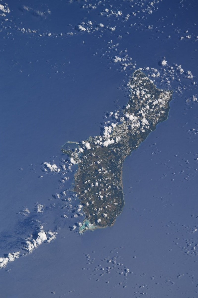
グアムは、海底火山によって造られたマリアナ諸島最大の島で、アメリカ合衆国の海外領土です。北部は珊瑚礁に囲まれた石灰質の平坦な台地で、南部は火山の丘陵地帯で、最高所はラムラム山で標高406m。1521年にポルトガルの探検家マゼランがヨーロッパ人として初めてグアム島に到達。1898年にアメリカとスペインの間で勃発した米西戦争にアメリカが勝利し、同年のパリ条約によりグアム島はフィリピン、プエルトリコとともにアメリカ合衆国に割譲されました。
地上の様子はこちらです。

参考文献: Oleg Artemyev’s Tweet
地球俯瞰画像を見る: LiVEARTH
[Earthview Wonders] No.672: Guam🇬🇺
Astronaut Oleg Artemyev captured from ISS Guam.
Guam is an unincorporated and organized territory of the United States in Micronesia in the western Pacific Ocean. The Mariana chain of which Guam is a part was created by collision of the Pacific and Philippine Sea tectonic plates, and it is the largest and southernmost of the Mariana Islands with the highest point at Mt. Lamlam at 406m. Since the 1960s, the economy has been supported by two industries: tourism and the United States Armed Forces. The indigenous Chamorros settled the island approximately 4,000 years ago. Guam was colonized by Spain in 1668 with settlers, and during the Spanish–American War, the United States captured Guam in 1898.
The local scenery on the ground is as follows.
Reference: Oleg Artemyev’s Tweet
See earthview photo gallery: LiVEARTH[:en][Earthview Wonders] No.672: Guam🇬🇺
Astronaut Oleg Artemyev captured from ISS Guam.
Guam is an unincorporated and organized territory of the United States in Micronesia in the western Pacific Ocean. The Mariana chain of which Guam is a part was created by collision of the Pacific and Philippine Sea tectonic plates, and it is the largest and southernmost of the Mariana Islands with the highest point at Mt. Lamlam at 406m. Since the 1960s, the economy has been supported by two industries: tourism and the United States Armed Forces. The indigenous Chamorros settled the island approximately 4,000 years ago. Guam was colonized by Spain in 1668 with settlers, and during the Spanish–American War, the United States captured Guam in 1898.
The local scenery on the ground is as follows.
Reference: Oleg Artemyev’s Tweet
See earthview photo gallery: LiVEARTH[:]