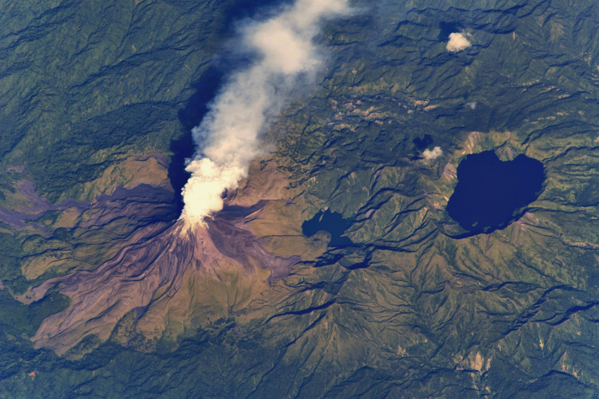
[:ja]セルゲイ・リャザンスキー宇宙飛行士がISSから撮影したソロモン諸島のブーゲンビル島の火山です。この活火山は1842年から30回以上も噴火しています。
ソロモン諸島は、南太平洋のメラネシアにある島嶼群、国家です。ただし、地理的にはソロモン諸島に属するブーゲンビル島は、国家の領域的にはパプアニューギニアに属します。自給自足的な経済と貨幣経済が併存している。経済格差が大きく、木材とコプラ、パーム油に鰹と鮪が主要品目です。海面上昇と海水による浸食の脅威に直面しており、第二次世界大戦後から現在までに5つのサンゴ礁の無人島が消失しました。自然環境に依存した生活を営む住民が多いため、気候変動は住民の生活に直接的な影響を与えています。
地上の様子はこちらです。

参考文献: Sergey Ryazansky’s Tweet
地球俯瞰画像を見る: LiVEARTH
[Earthview Wonders] No.692: Bagana Volcano, Solomon Islands🇸🇧
Astronaut Sergey Ryazansky captured from ISS Bagana Volcano, Solomon Islands. This volcano has erupted more than 30 times since 1842.
Solomon Islands is a sovereign state consisting of six major islands and over 900 smaller islands in Oceania lying to the east of Papua New Guinea. The islands contain several active and dormant volcanoes. Solomon Islands’ per-capita GDP of $600 ranks it as a lesser developed nation, and more than 75% of its labour force is engaged in subsistence and fishing. Other important cash crops and exports include copra and palm oil.
The local scenery on the ground is as follows.
Reference: Sergey Ryazansky’s Tweet
See earthview photo gallery: LiVEARTH[:en][Earthview Wonders] No.692: Bagana Volcano, Solomon Islands🇸🇧
Astronaut Sergey Ryazansky captured from ISS Bagana Volcano, Solomon Islands. This volcano has erupted more than 30 times since 1842.
Solomon Islands is a sovereign state consisting of six major islands and over 900 smaller islands in Oceania lying to the east of Papua New Guinea. The islands contain several active and dormant volcanoes. Solomon Islands’ per-capita GDP of $600 ranks it as a lesser developed nation, and more than 75% of its labour force is engaged in subsistence and fishing. Other important cash crops and exports include copra and palm oil.
The local scenery on the ground is as follows.
Reference: Sergey Ryazansky’s Tweet
See earthview photo gallery: LiVEARTH[:]