[:ja]セルゲイ・リャザンスキー宇宙飛行士がISSから撮影したアフリカ、チャドのティベスティ山地とトゥシデ山です。
ティベスティ山地はチャド北部とリビア南部のサハラ砂漠内に存在する山地で、サハラ砂漠最高地点のエミクーシ山(3415m)や、トゥシデ山(3315m)など複数の3000m級の高峰を持つ死火山地帯です。トゥシデ火山の画像からは、溶岩の広がりの様子がよくわかります。
地上の様子はこちらです。

参考文献: Sergey Ryazansky’s Tweet
地球俯瞰画像を見る: LiVEARTH
[Earthview Wonders] No.725: Tibesti Mountains🇹🇩
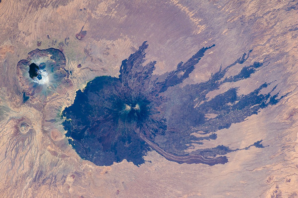
Astronaut Sergey Ryazansky captured from ISS Tarso Tousside of Tibesti Mountains, Chad.
The Tibesti Mountains lie in the north of Chad, Africa. The highest peak in the range, Emi Koussi (3,445m), is the highest point in both Chad and the Sahara. Major lava flows have formed vast plateaus that overlie Paleozoic sandstone. The volcanic activity was the result of a continental hotspot that arose during the Oligocene and continued in some places until the Holocene. In the image shows Toussidé or Tarso Toussidé (3,265m) which is a potentially active stratovolcano in Chad. The volcano is the source of a number of lava flows, which have flowed westward away from Toussidé and east into the Yirrigué caldera.
The local scenery on the ground is as follows.
Reference: Sergey Ryazansky’s Tweet
See earthview photo gallery: LiVEARTH[:en][Earthview Wonders] No.725: Tibesti Mountains🇹🇩
Astronaut Sergey Ryazansky captured from ISS Tarso Tousside of Tibesti Mountains, Chad.
The Tibesti Mountains lie in the north of Chad, Africa. The highest peak in the range, Emi Koussi (3,445m), is the highest point in both Chad and the Sahara. Major lava flows have formed vast plateaus that overlie Paleozoic sandstone. The volcanic activity was the result of a continental hotspot that arose during the Oligocene and continued in some places until the Holocene. In the image shows Toussidé or Tarso Toussidé (3,265m) which is a potentially active stratovolcano in Chad. The volcano is the source of a number of lava flows, which have flowed westward away from Toussidé and east into the Yirrigué caldera.
The local scenery on the ground is as follows.
Reference: Sergey Ryazansky’s Tweet
See earthview photo gallery: LiVEARTH[:]