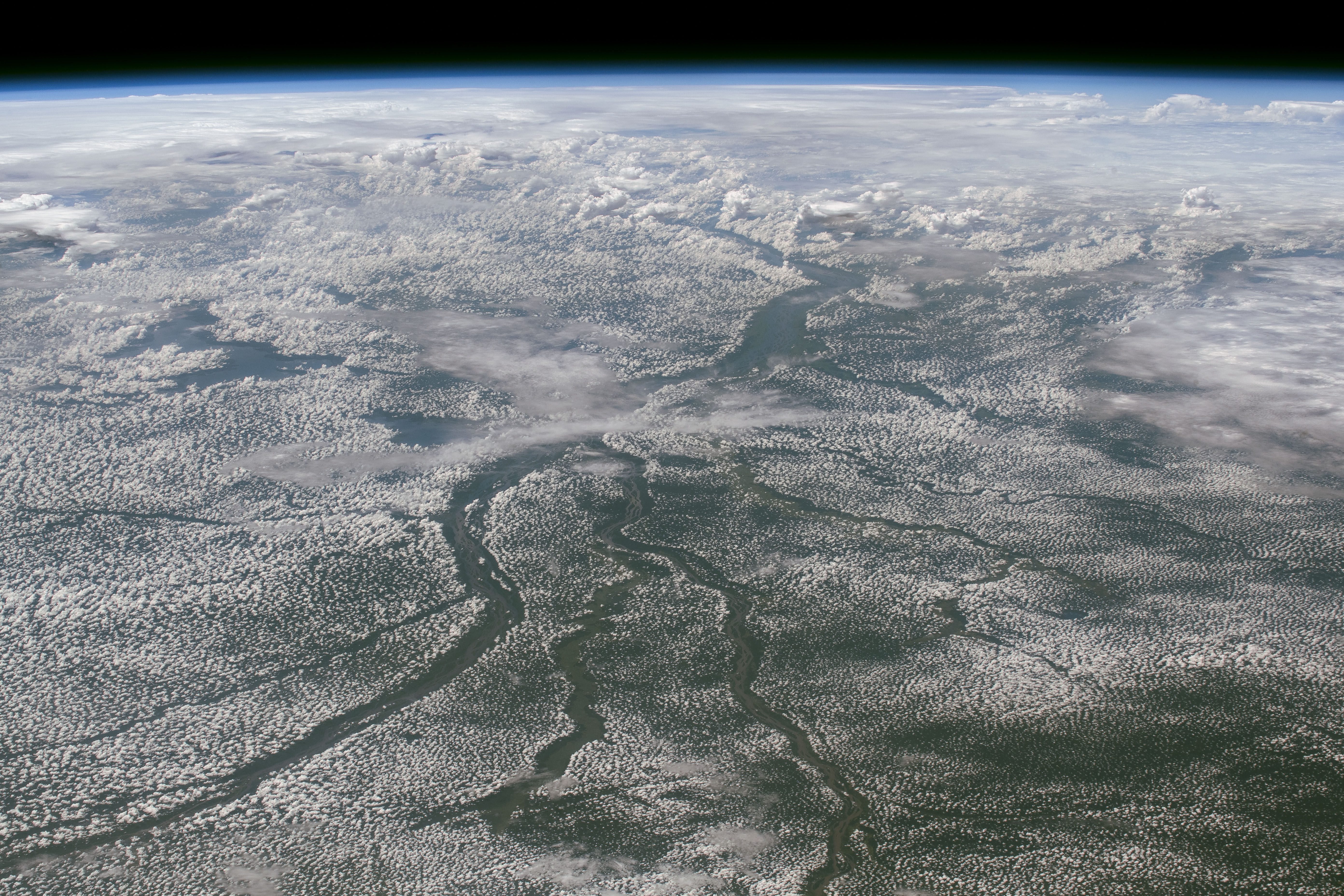
[:ja]宇宙飛行士がISSから撮影したムバンダカ付近のコンゴ川の流域です。キンシャサ、ブラザビルは遠くの雷雲の付近にあります。また、白いのは雪ではなく雲です。
コンゴ川(旧ザイール川)は、中部アフリカのコンゴ盆地を蛇行しながら流れ、大西洋に至るアフリカ大陸2番目の長さ(4,700km)を誇る河川です。流域面積と流量はアマゾン川に次いで世界2位であり、流域の熱帯雨林もアマゾン川に次ぐ広さを持ちます。流域中部は赤道直下で1年中雨が降り、またボヨマ滝の南で北に赤道を越え、ムバンダカ近郊で南に赤道を越えるため、支流が赤道をはさんで南北に分散しており、雨季の時期が各支流によって違うため増水期が分散しており、そのため本流の流量はほぼ一定です。世界第2位の巨大な流量を持ち、さらに流量の季節変動がほとんどない上、流量の最も多くなる下流部に大きな高低差が存在するため、電力の端境期のない良質の水力発電源として古くから注目されてきました。
地上の様子はこちらです。

参考文献: Cloudy Congo River Basin (NASA Earth Observatory)
地球俯瞰画像を見る: LiVEARTH
[Earthview Wonders] No.781: Congo River
Astronauts on board ISS Congo River, near Mbandaka. In the distance under the cumulonimbus cloulds are Kinshasa and Brazzaville. White land is is not not covered with snow but clouds.
The great Congo River, formerly known as the Zaire River, is the second longest river in Africa (4,370km), shorter only than the Nile, as well as the second largest river in the world by discharge volume, following only the Amazon. It is also the world’s deepest recorded river, with measured depths in excess of 220m. The river and its tributaries flow through the Congo Rainforest, the second largest rain forest area in the world, second only to the Amazon Rainforest in South America. The river is potentially valuable for hydroelectric power, and the Inga Dams below Pool Malebo are first to exploit the Congo river.
The local scenery on the ground is as follows.
Reference: Cloudy Congo River Basin (NASA Earth Observatory)
See earthview photo gallery: LiVEARTH[:en][Earthview Wonders] No.781: Congo River
Astronauts on board ISS Congo River, near Mbandaka. In the distance under the cumulonimbus cloulds are Kinshasa and Brazzaville. White land is is not not covered with snow but clouds.
The great Congo River, formerly known as the Zaire River, is the second longest river in Africa (4,370km), shorter only than the Nile, as well as the second largest river in the world by discharge volume, following only the Amazon. It is also the world’s deepest recorded river, with measured depths in excess of 220m. The river and its tributaries flow through the Congo Rainforest, the second largest rain forest area in the world, second only to the Amazon Rainforest in South America. The river is potentially valuable for hydroelectric power, and the Inga Dams below Pool Malebo are first to exploit the Congo river.
The local scenery on the ground is as follows.
Reference: Cloudy Congo River Basin (NASA Earth Observatory)
See earthview photo gallery: LiVEARTH[:]