[:ja]ルカ・パルミタノ宇宙飛行士がISSから撮影した米マサチューセッツ州のボストン、プリマスと東端のケープコッド岬です。
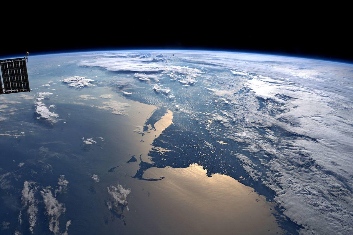
ケープコッドの対岸のプリマスはピルグリムファーザーズの上陸地です。ケープコッドの小さな町の海洋的性格や海浜が夏季の観光資源となっています。ケープコッドは元々本土と一体でしたが、1914年に開通したケープコッド運河を間に挟んでいます。コッドは英語で「タラ」を意味しますが、沖合はタラの漁場となっています。ケープコッドは北アメリカで最初にヨーロッパ人が入った場所の一つで、ケープコッドの15の町はゆっくりと成長しました。
地上の様子はこちらです。
:max_bytes(150000):strip_icc():format(webp)/cape-cod-national-seashore-56a3f2303df78cf772800daa.jpg)
参考文献: Luca Parmitano’s Tweet
地球俯瞰画像を見る: LiVEARTH
[Earthview Wonders] No.884: Cape Cod🇺🇸
Astronaut Luca Parmitano captured from ISS Boston, Plymouth and Cape Cod, Massachusetts, U.S.
Cape Cod is a geographic cape extending into the Atlantic Ocean from the southeastern corner of mainland Massachusetts. Its historic, maritime character and ample beaches attract heavy tourism during the summer months. Since 1914, most of Cape Cod has been separated from the mainland by the Cape Cod Canal. Although Cape Cod’s weather is typically more moderate than inland locations, on occasion it takes the brunt of extreme weather systems such as the Blizzard of 2005 and Hurricane Bob. Because of the influence of the Atlantic Ocean, temperatures are typically a few degrees lower in the summer and a few degrees higher in the winter than the adjacent mainland.
The local scenery on the ground is as follows.
Reference: Luca Parmitano’s Tweet
See earthview photo gallery: LiVEARTH[:en][Earthview Wonders] No.884: Cape Cod🇺🇸
Astronaut Luca Parmitano captured from ISS Boston, Plymouth and Cape Cod, Massachusetts, U.S.
Cape Cod is a geographic cape extending into the Atlantic Ocean from the southeastern corner of mainland Massachusetts. Its historic, maritime character and ample beaches attract heavy tourism during the summer months. Since 1914, most of Cape Cod has been separated from the mainland by the Cape Cod Canal. Although Cape Cod’s weather is typically more moderate than inland locations, on occasion it takes the brunt of extreme weather systems such as the Blizzard of 2005 and Hurricane Bob. Because of the influence of the Atlantic Ocean, temperatures are typically a few degrees lower in the summer and a few degrees higher in the winter than the adjacent mainland.
The local scenery on the ground is as follows.
Reference: Luca Parmitano’s Tweet
See earthview photo gallery: LiVEARTH[:]