[:ja]日本で開催中のラグビーワールドカップでイングランドが決勝戦まで進みました。ルカ・パルミタノ宇宙飛行士がISSから撮影したイギリスのイングランドです。画像は手前にバーミンガム、奥にシェフィールド、リーズ、マンチェスター、リバプール、遠方にマン島、湖水地方までが写っています。
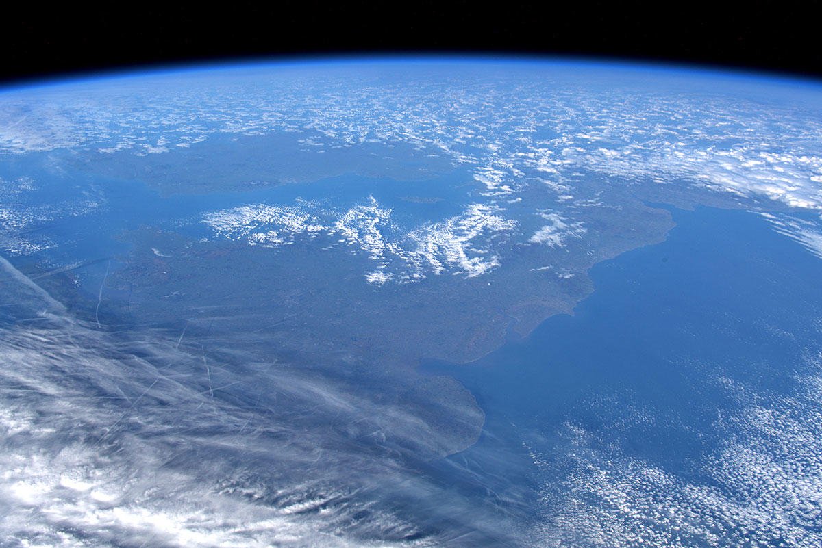
イングランドの大部分は岩の多い低地からなり、北西の山がちな地域(湖水地方のカンブリア山脈)、北部から南イングランドの泥炭質にいたります。イングランドには標高1,000mを超える地点はなく、大半はなだらかな丘陵地及び平原で占められており、国土のおよそ90%が可住地となっています。森林は少なく、日本が国土の3分の2が森林で覆われているのに対し、イギリスの森林率は11%ほどです。イギリスの気候は一般的に温暖ですが、地域による気候の差異はあり、特に高度と海からの距離によって大きく左右されます。一般に、南は北より暖かく西は東より湿潤です。イギリスは温暖なメキシコ湾流の影響を受け、ニューファンドランド島といった同緯度のほかの地域より格段に暖かくなっています。また、北大西洋海流がもたらす南西の風により、半分以上の日が曇りです。
湖水地方の地上の様子はこちらです。

参考文献: Luca Parmitano’s Tweet
地球俯瞰画像を見る: LiVEARTH
[Earthview Wonders] No.885: England🏴
Congratulations to England for making its way to the finals of Rugby World Cup. Astronaut Luca Parmitano captured from ISS England, U.K.. The photo shows Birmingham, Sheffield, Leeds, Manchester, Liverpool, Mann Island and Lake District.
England is separated from continental Europe by the North Sea to the east and the English Channel to the south. The Industrial Revolution began in 18th-century England, transforming its society into the world’s first industrialised nation. England’s terrain is chiefly low hills and plains, especially in central and southern England. However, there is upland and mountainous terrain in the north (for example, the Lake District and Pennines) and in the west. Geographically England includes the central and southern two-thirds of the island of Great Britain, plus such offshore islands as the Isle of Wight and the Isles of Scilly. Important influences on the climate of England are its proximity to the Atlantic Ocean, its northern latitude and the warming of the sea by the Gulf Stream. Rainfall is higher in the west, and parts of the Lake District receive more rain than anywhere else in the country.
The local scenery on the ground is as follows.
Reference: Luca Parmitano’s Tweet
See earthview photo gallery: LiVEARTH[:en][Earthview Wonders] No.885: England🏴
Congratulations to England for making its way to the finals of Rugby World Cup. Astronaut Luca Parmitano captured from ISS England, U.K.. The photo shows Birmingham, Sheffield, Leeds, Manchester, Liverpool, Mann Island and Lake District.
England is separated from continental Europe by the North Sea to the east and the English Channel to the south. The Industrial Revolution began in 18th-century England, transforming its society into the world’s first industrialised nation. England’s terrain is chiefly low hills and plains, especially in central and southern England. However, there is upland and mountainous terrain in the north (for example, the Lake District and Pennines) and in the west. Geographically England includes the central and southern two-thirds of the island of Great Britain, plus such offshore islands as the Isle of Wight and the Isles of Scilly. Important influences on the climate of England are its proximity to the Atlantic Ocean, its northern latitude and the warming of the sea by the Gulf Stream. Rainfall is higher in the west, and parts of the Lake District receive more rain than anywhere else in the country.
The local scenery on the ground is as follows.
Reference: Luca Parmitano’s Tweet
See earthview photo gallery: LiVEARTH[:]