[:ja]セルゲイ・リャザンスキー宇宙飛行士がISSから撮影したハン・テングリです。
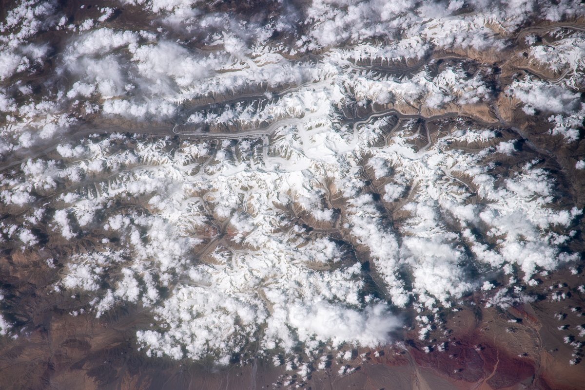
ハン・テングリは、天山山脈でポベーダ山に次ぐ2番目の高さの山で、中華人民共和国新疆ウイグル自治区(東トルキスタン)、カザフスタン、キルギス3国の国境線上(三国国境)にあり、海抜は7010mです。かつてはその急峻さから天山山脈の最高峰と思われていました。標高4200mのベースキャンプには徒歩によるキャラバンではなくヘリコプターで移動する為、国際キャンプ場のあるカルカラを拠点に事前の高度馴化を行うことが必要となります。
地上の様子はこちらです。

参考文献: Sergey Ryazansky’s Tweet
地球俯瞰画像を見る: LiVEARTH
[Earthview Wonders] No.920: Khan Tengri🇨🇳🇰🇬🇰🇿
Astronaut Sergey Ryazansky captured from ISS Khan Tengri at the border of China, Kyrgyzstan and Kazakhstan.
Khan Tengri is a mountain of the Tian Shan mountain range. It is located on the China—Kyrgyzstan—Kazakhstan border, east of lake Issyk Kul. Its glacial cap rises to 7,010m. For this reason, in mountaineering circles, including for the Soviet Snow Leopard award criteria, it is considered a 7,000-metre peak. The name “Khan Tengri” literally means “King Heaven” in Kazakh and possibly references the deity Tengri. In some other local languages, it is known as Khan Tangiri Shyngy, Kan-Too Chokusu, Pik Khan-Tengry, and Hantengri Feng. It is also the world’s most northern 7,000m peak, notable because peaks of high latitude have a shorter climbing season, generally more severe weather and thinner air.
The local scenery on the ground is as follows.
Reference: Sergey Ryazansky’s Tweet
See earthview photo gallery: LiVEARTH[:en][Earthview Wonders] No.920: Khan Tengri🇨🇳🇰🇬🇰🇿
Astronaut Sergey Ryazansky captured from ISS Khan Tengri at the border of China, Kyrgyzstan and Kazakhstan.
Khan Tengri is a mountain of the Tian Shan mountain range. It is located on the China—Kyrgyzstan—Kazakhstan border, east of lake Issyk Kul. Its glacial cap rises to 7,010m. For this reason, in mountaineering circles, including for the Soviet Snow Leopard award criteria, it is considered a 7,000-metre peak. The name “Khan Tengri” literally means “King Heaven” in Kazakh and possibly references the deity Tengri. In some other local languages, it is known as Khan Tangiri Shyngy, Kan-Too Chokusu, Pik Khan-Tengry, and Hantengri Feng. It is also the world’s most northern 7,000m peak, notable because peaks of high latitude have a shorter climbing season, generally more severe weather and thinner air.
The local scenery on the ground is as follows.
Reference: Sergey Ryazansky’s Tweet
See earthview photo gallery: LiVEARTH[:]