[:ja]宇宙飛行士がISSから撮影した中国、カザフスタン、キルギスの国境にまたがる天山山脈です。
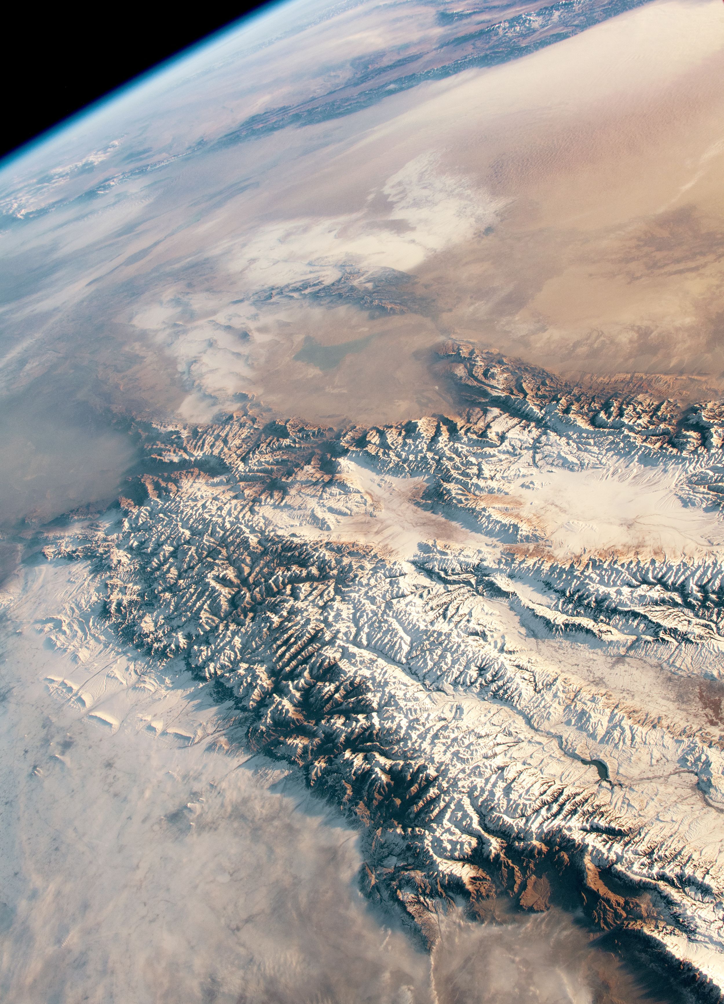
天山山脈は中央アジア、中国のトルファン盆地の北の山々から始まって、西へタクラマカン砂漠の北および西のカザフスタン、キルギスの中国との国境地帯にある山々に至るまでの山脈です。ウイグル語名は天の山を意味するテンリ・タグ(تەڭرىتاغ Tengri tagh)といい、漢名はこれに由来します。天山山脈にはアジア地域における氷河の多くが存在しており、季節による雪解けにより、低地に堆積物を運びます。また、その過程で扇状地が形成されます。
地上の様子はこちらです。

参考文献: Snow and Sand in Central Asia (NASA Earth Observatory)
地球俯瞰画像を見る: LiVEARTH
[Earthview Wonders] No.973: Tian Shan Mountains🇨🇳🇰🇿🇰🇬
Astronaut on board ISS Tian Shan Mountains that is located in China, Kazakhstan and Kyrgyzstan.
The Tian Shan, also known as the Tengri Tagh or Tengir-Too, meaning the Mountains of Heaven or the Heavenly Mountain, is a large system of mountain ranges located in Central Asia. The highest peak in the Tian Shan is Jengish Chokusu, at 7,439m high. Its lowest point is the Turpan Depression, which is 154 m below sea level. Many of Asia’s major glaciers in the Tien Shan. In the spring and summer, the melting of ice and snow replenishes local rivers and transports eroded sediment to valleys. Alluvial fans deposit sediment perpendicular to the surrounding mountain ranges that get reworked, eroded, and transported farther by wind.
The local scenery on the ground is as follows.
Reference: Snow and Sand in Central Asia (NASA Earth Observatory)
See earthview photo gallery: LiVEARTH[:en][Earthview Wonders] No.973: Tian Shan Mountains🇨🇳🇰🇿🇰🇬
Astronaut on board ISS Tian Shan Mountains that is located in China, Kazakhstan and Kyrgyzstan.
The Tian Shan, also known as the Tengri Tagh or Tengir-Too, meaning the Mountains of Heaven or the Heavenly Mountain, is a large system of mountain ranges located in Central Asia. The highest peak in the Tian Shan is Jengish Chokusu, at 7,439m high. Its lowest point is the Turpan Depression, which is 154 m below sea level. Many of Asia’s major glaciers in the Tien Shan. In the spring and summer, the melting of ice and snow replenishes local rivers and transports eroded sediment to valleys. Alluvial fans deposit sediment perpendicular to the surrounding mountain ranges that get reworked, eroded, and transported farther by wind.
The local scenery on the ground is as follows.
Reference: Snow and Sand in Central Asia (NASA Earth Observatory)
See earthview photo gallery: LiVEARTH[:]