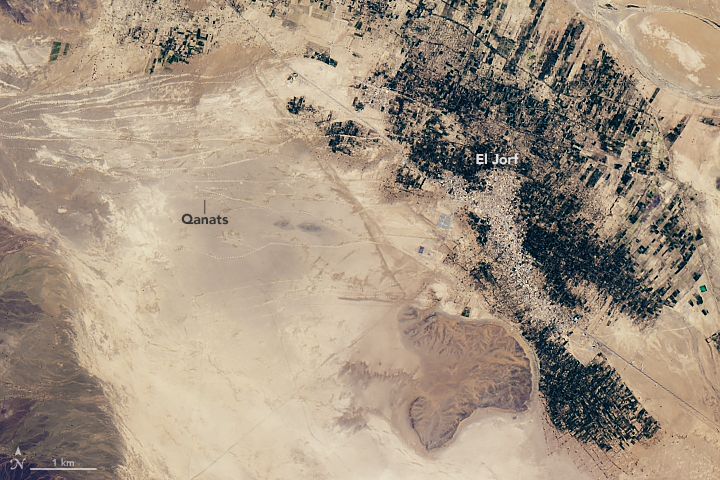
[:ja]NASAの地球観測衛星Landsatが撮影した、モロッコ南東のタフィラルト・オアシスとその西側に広がる筋状の地下用水路カナートです。
カナートは山麓の扇状地などにおける地下水を水源とし、傾斜を利用しポンプなしで水を運びます。地下に水路を設け、蒸発を防ぐ設計になっています。ペルシア帝国が古代メソポタミア文明を凌駕した灌漑施設とされています。
地上のカナートの様子はこちらです。

参考文献: Ancient Waterways in Morocco
ウェブ地球儀で地球俯瞰画像を見る: LiVEARTH
[Earthview Wonders] No.144: Ancient Waterways in Morocco
NASA’s Landsat satellite captured Tafilalt Oasis of southeastern Morocco and and quanats, the underground water channels in the west of El Jorf.
Quanats are an old system of water supply for irrigation or drinking, consisting underground channels to transport water down slopes without active pumping. Underground waterways avoid water loss to evaporation.
Actual quanats on the ground looks like this.
Reference: Ancient Waterways in Morocco
See earthview photo gallery with web-globe: LiVEARTH[:en][Earthview Wonders] No.144: Ancient Waterways in Morocco
NASA’s Landsat satellite captured Tafilalt Oasis of southeastern Morocco and and quanats, the underground water channels in the west of El Jorf.
Quanats are an old system of water supply for irrigation or drinking, consisting underground channels to transport water down slopes without active pumping. Underground waterways avoid water loss to evaporation.
Actual quanats on the ground looks like this.
Reference: Ancient Waterways in Morocco
See earthview photo gallery with web-globe: LiVEARTH[:]