[:ja]大西宇宙飛行士がISSから撮影した米国🇺🇸西海岸のサンホアキン・バレーです。サンホアキン・バレーは東のシェラネバダ山脈と西のカリフォルニア海岸山脈の間の低地です。画面中央付近のサンフランシスコを含むベイエリアには霧が立ち込めています。
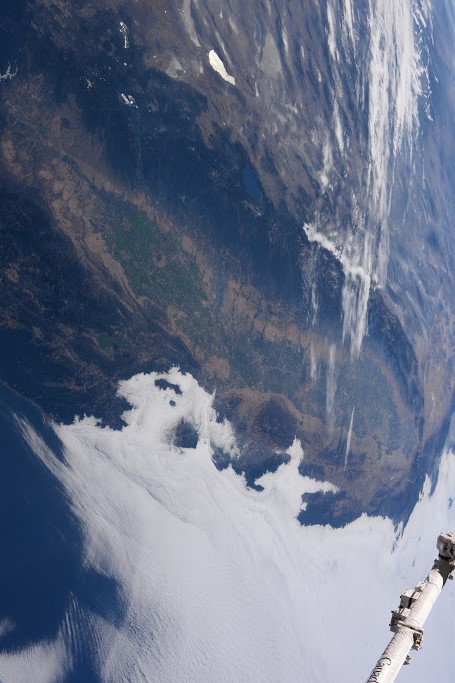
ある推計によれば、カリフォルニア州で生産される農業生産物は全米の12.8%に相当し、その大半がサンホアキン・バレーで生産されているとされています。
地上の様子はこちらです。

参考文献: Takuya Onishi’s Post
ウェブ地球儀で地球俯瞰画像を見る: LiVEARTH
[Earthview Wonders] No.178: San Joaquin Valley🇺🇸
Astronaut Takuya Onishi captured from the ISS the San Joaquin Valley of the U.S.🇺🇸. San Joaquin Valley is the valley between the Sierra Nevada in the east and California coastal ranges in the west. Dense fog covers Bay Area including San Francisco in the middle of the image.
By some estimates, the San Joaquin Valley produces the majority of the 12.8% of the US’ agricultural production that comes from California.
This is the scenery of the valley on the ground.
Reference: Takuya Onishi’s Post
See earthview photo gallery with web-globe: LiVEARTH[:en][Earthview Wonders] No.178: San Joaquin Valley🇺🇸
Astronaut Takuya Onishi captured from the ISS the San Joaquin Valley of the U.S.🇺🇸. San Joaquin Valley is the valley between the Sierra Nevada in the east and California coastal ranges in the west. Dense fog covers Bay Area including San Francisco in the middle of the image.
By some estimates, the San Joaquin Valley produces the majority of the 12.8% of the US’ agricultural production that comes from California.
This is the scenery of the valley on the ground.
Reference: Takuya Onishi’s Post
See earthview photo gallery with web-globe: LiVEARTH[:]