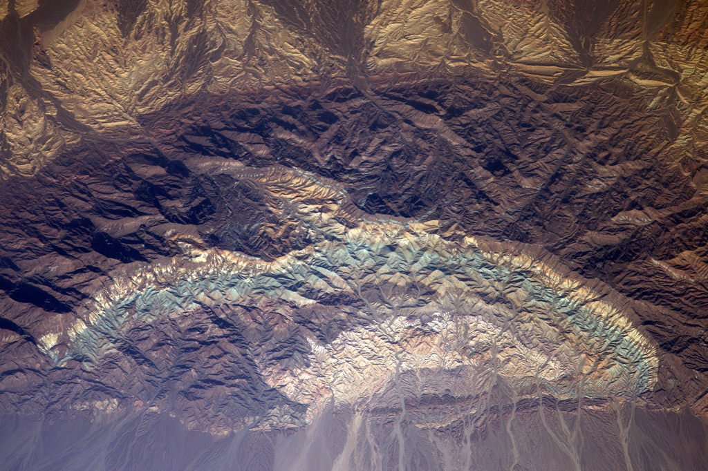
[:ja]トーマス・ペスケット宇宙飛行士がISSから撮影したイラン北部の環境保護区、カヴィール国立公園です。カヴィール国立公園は2つの塩湖の間にあり、公園の中心付近にはブラック・マウンテンと呼ばれる、半円型の岩場が存在します。宇宙から見ると薄水色の岩場が美しいです。
イラン高原にあるカヴィール砂漠はアフガニスタン、パキスタン、インドへと砂漠地帯が広がり、古来から、マルコ・ポーロなど旅人が通商路として横断していました。
地上の様子はこちらです。


参考文献: Thomas Pesquet’s Tweet
ウェブ地球儀で地球俯瞰画像を見る: LiVEARTH
[Earthview Wonders] No.208: Kavir National Park of Iran🇮🇷
Astronaut Thomas Pesquet captured from ISS the Kavir National Park, the protected ecological zone in northern Iran. The Park sits on the western end of one of Iran’s two major deserts. Siahkuh (Black Mountain), a large, semi-circular rock outcropping sits in roughly the park’s center. The bluish color of the Black Mountain is beautiful when seen from space.
Kavir Desert lies in the middle of the Iranian Plateau and reaches Afghanistan, Pakistan and India which merchants such as Marco Polo traveled across.
The scenery on the ground is as follows.
Reference: Thomas Pesquet’s Tweet
See earthview photo gallery with web-globe: LiVEARTH
[:en][Earthview Wonders] No.208: Kavir National Park of Iran🇮🇷
Astronaut Thomas Pesquet captured from ISS the Kavir National Park, the protected ecological zone in northern Iran. The Park sits on the western end of one of Iran’s two major deserts. Siahkuh (Black Mountain), a large, semi-circular rock outcropping sits in roughly the park’s center. The bluish color of the Black Mountain is beautiful when seen from space.
Kavir Desert lies in the middle of the Iranian Plateau and reaches Afghanistan, Pakistan and India which merchants such as Marco Polo traveled across.
The scenery on the ground is as follows.
Reference: Thomas Pesquet’s Tweet
See earthview photo gallery with web-globe: LiVEARTH
[:]