[:ja]EUの地球観測衛星Sentinel3が撮影したコンゴ川です。衛星画像はコンゴ民主共和国とアンゴラの国境付近の大西洋の河口で、土砂が海に流れ出している様子がわかります。
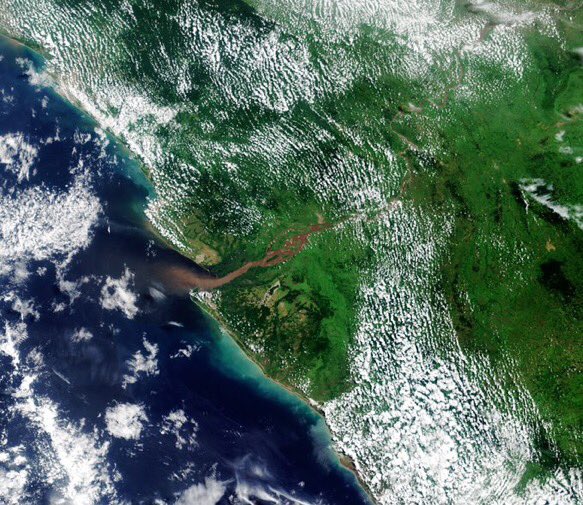
コンゴ川はアフリカ大陸2番目の長さ(4,700km)を誇ります。コンゴ民主共和国南東部のカタンガ高原南部、ザンビアとの国境近くに端を発し、中部アフリカのコンゴ盆地を蛇行しながら流れ、大西洋に至ります。
ヨーロッパ人との接触によって、1600年ごろにはコンゴ川流域に新大陸原産のキャッサバが持ち込まれました。キャッサバはバナナより手間がかからず、やせた土地でもよく生育したため、この地域に農業革命をもたらしました。
地上の様子はこちらです。

参考文献: Copernicus EU
ウェブ地球儀で地球俯瞰画像を見る: LiVEARTH
[Earthview Wonders] No.225: Congo River🇨🇩🇨🇬
EU’s Sentinel3 satellite captured Congo River. The satellite image is at the mouth of the river on the Atlantic Ocean, just in between the Democratic Republic of Congo and Angola. The sediment of the river is pushed out to the sea.
The Congo River is the second longest (4,700km) in Africa. It originates from Katanga Highland near Zambia, and flows through Congo Basin to finally reach the Atlantic Ocean.
In 17the century agricultural innovation took place in this area when Europeans brought to this area cassava which grows in arid land.
The local scenery on the ground is as follows.
Reference: Copernicus EU
See earthview photo gallery with web-globe: LiVEARTH[:en][Earthview Wonders] No.225: Congo River🇨🇩🇨🇬
EU’s Sentinel3 satellite captured Congo River. The satellite image is at the mouth of the river on the Atlantic Ocean, just in between the Democratic Republic of Congo and Angola. The sediment of the river is pushed out to the sea.
The Congo River is the second longest (4,700km) in Africa. It originates from Katanga Highland near Zambia, and flows through Congo Basin to finally reach the Atlantic Ocean.
In 17the century agricultural innovation took place in this area when Europeans brought to this area cassava which grows in arid land.
The local scenery on the ground is as follows.
Reference: Copernicus EU
See earthview photo gallery with web-globe: LiVEARTH[:]