[:ja]ESAの地球観測衛星Sentinel-2Aが撮影した、ボツワナ最大の行政区セントラル地区です。
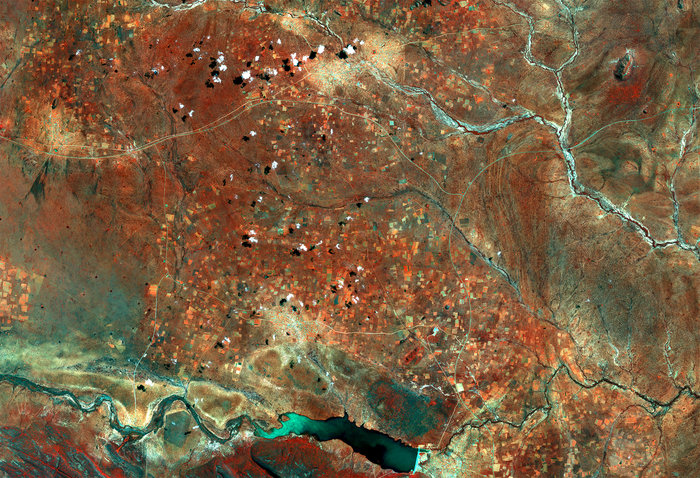
白い部分が植生が少なくなっている村などの人口密集地帯です。逆に、赤い部分が植生が豊かな場所で、画像下方のロットセイン川付近の畑などが代表的です。貯水池とダムも見えています。
地上の様子はこちらです。

ちなみに、北東のザンビアとの国境は約150mしかなく、世界で一番短い国境線です。
参考文献: Central District, Botswana (ESA)
ウェブ地球儀で地球俯瞰画像を見る: LiVEARTH
[Earthview Wonders] No.431: Botswana🇧🇼
ESA’s Sentinel-2A satellite captured the Central District of Botswana.
Rivers and roads cut through the landscape, while the bright, circular areas represent villages where the vegetation has been cleared away. Areas of thicker vegetation appear red, such as in the fields or along the bottom of the image in the Tswapong Hills south of the Lotsane River.
The local scenery on the ground is as follows.
Reference: Central District, Botswana (ESA)
See earthview photo gallery with web-globe: LiVEARTH[:en][Earthview Wonders] No.431: Botswana🇧🇼
ESA’s Sentinel-2A satellite captured the Central District of Botswana.
Rivers and roads cut through the landscape, while the bright, circular areas represent villages where the vegetation has been cleared away. Areas of thicker vegetation appear red, such as in the fields or along the bottom of the image in the Tswapong Hills south of the Lotsane River.
The local scenery on the ground is as follows.
Reference: Central District, Botswana (ESA)
See earthview photo gallery with web-globe: LiVEARTH[:]