[:ja]ランディ・ブレズニク宇宙飛行士がISSから撮影したカーボデルデのフォゴ山です。
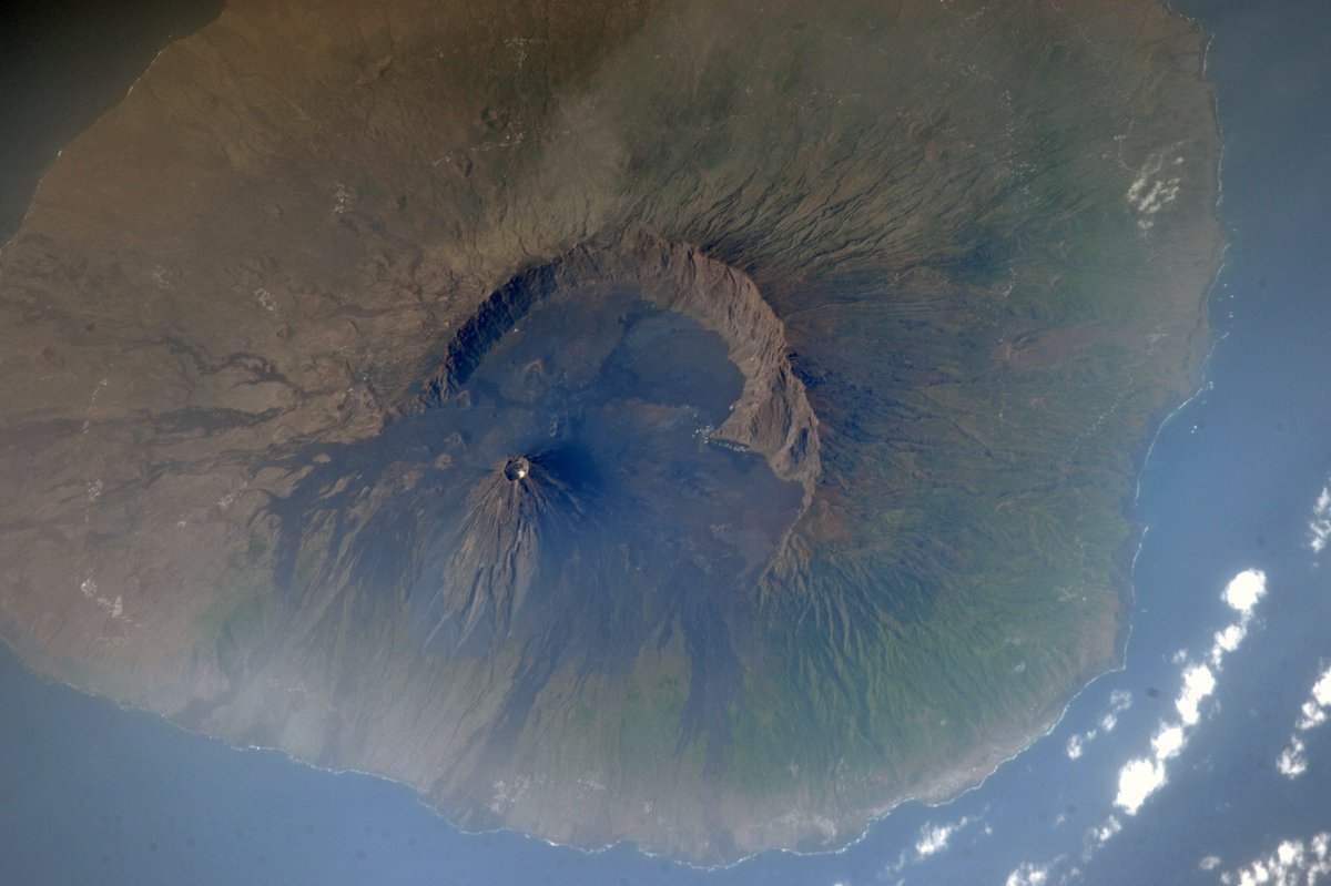
カーボベルデ諸島は、西アフリカ大陸部のセネガルから約375km離れた場所にあり、大小15の火山群島からなり、最高峰はフォゴ島のフォゴ山(2829m)です。カーボベルデは、プレートの運動により大西洋が拡大中に、ホットスポットでマントルの部分融解融で発生したマグマが噴出した玄武岩類が諸島を形成しました。1460年にポルトガル人が入植を開始し、マデイラ諸島やアソーレス諸島同様、砂糖を生産しようとしましたが、サヘルの延長にある雨の降らない厳しい気候や土壌の不毛さによって失敗しました。熱く乾燥した気候で旱魃が何年も続く事があり、農作物などが被害を受けやすい上、山岳的な様相を呈し、荒涼とした絶壁や荒地が広がり、国全体が深刻な水不足に悩まされています。
地上の様子はこちらです。

参考文献: Randy Bresnik’s Tweet
ウェブ地球儀で地球俯瞰画像を見る: LiVEARTH
[Earthview Wonders] No.472: Mt. Fogo, Cape Verde🇨🇻
Astronaut Randy Bresnik captured from ISS Mt. Fogo, Cape Verde.
Cape Verde is in the Atlantic Ocean 275km away from Senegal. The island country consists of 15 volcanic islands with the highest Mt. Fogo (2829m). Portuguese explorers discovered and colonized the islands in 1460, and tried to produce sugar just like Madeira and Azores Islands, which turned out to be failure due to harsh climate.
The local scenery on the ground is as follows.
Reference: Randy Bresnik’s Tweet
See earthview photo gallery with web-globe: LiVEARTH[:en][Earthview Wonders] No.472: Mt. Fogo, Cape Verde🇨🇻
Astronaut Randy Bresnik captured from ISS Mt. Fogo, Cape Verde.
Cape Verde is in the Atlantic Ocean 275km away from Senegal. The island country consists of 15 volcanic islands with the highest Mt. Fogo (2829m). Portuguese explorers discovered and colonized the islands in 1460, and tried to produce sugar just like Madeira and Azores Islands, which turned out to be failure due to harsh climate.
The local scenery on the ground is as follows.
Reference: Randy Bresnik’s Tweet
See earthview photo gallery with web-globe: LiVEARTH[:]