[:ja]NASAの地球観測衛星Terraが撮影したボツワナのマカディカディ塩湖です。
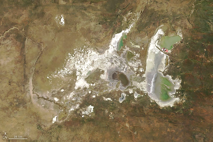
マカディカディ塩湖は、ボツワナ北部、カラハリ砂漠に広がる塩湖で、雨季にのみ水がたまりますが、普段は乾燥した塩類平原が広がっています。塩湖の主な水源はジンバブエのブラワヨ周辺から流れてくるナタ川とオカバンゴ・デルタから流れてくるボテティ川です。かつてカラハリ砂漠には現在の4倍に及ぶマカディカディ湖と呼ばれる巨大湖がありましたが、気候の乾燥化とともに縮小し、やがてマカディカディ塩湖を残して消滅しました。マカディカディ塩湖周辺には石器が豊富に出土し、完新世初期にはすでに人間が居住していたと考えられています。
地上の様子はこちらです。

参考文献: Makgadikgadi Salt Pans (NASA Earth Observatory)
ウェブ地球儀で地球俯瞰画像を見る: LiVEARTH
[Earthview Wonders] No.553: Makgadikadi Pan🇧🇼
NASA’s Terra satellite captured Makgadikadi Pan, Botswana.
The Makgadikgadi Pan (Botswana salt flats) is one of the largest salt flats in the world. The pan is all that remains of the formerly enormous Lake Makgadikgadi, which once covered an area larger than Switzerland, but dried up several thousand years ago. A dry, salty, clay crust most of the year, the pans are seasonally covered with water and grass, and are then a refuge for birds and animals in this very arid part of the world. The climate is hot and dry, but with regular annual rains. The main water source is the Nata River, called Amanzanyama in Zimbabwe, and the Boteti River from the Okavango Delta.
The local scenery on the ground is as follows.
Reference: Makgadikgadi Salt Pans (NASA Earth Observatory)
See earthview photo gallery with web-globe: LiVEARTH[:en][Earthview Wonders] No.553: Makgadikadi Pan🇧🇼
NASA’s Terra satellite captured Makgadikadi Pan, Botswana.
The Makgadikgadi Pan (Botswana salt flats) is one of the largest salt flats in the world. The pan is all that remains of the formerly enormous Lake Makgadikgadi, which once covered an area larger than Switzerland, but dried up several thousand years ago. A dry, salty, clay crust most of the year, the pans are seasonally covered with water and grass, and are then a refuge for birds and animals in this very arid part of the world. The climate is hot and dry, but with regular annual rains. The main water source is the Nata River, called Amanzanyama in Zimbabwe, and the Boteti River from the Okavango Delta.
The local scenery on the ground is as follows.
Reference: Makgadikgadi Salt Pans (NASA Earth Observatory)
See earthview photo gallery with web-globe: LiVEARTH[:]