[:ja]アレックス・ゲルスト宇宙飛行士がISSから撮影したニュージーランド北島のルアペフ山です。
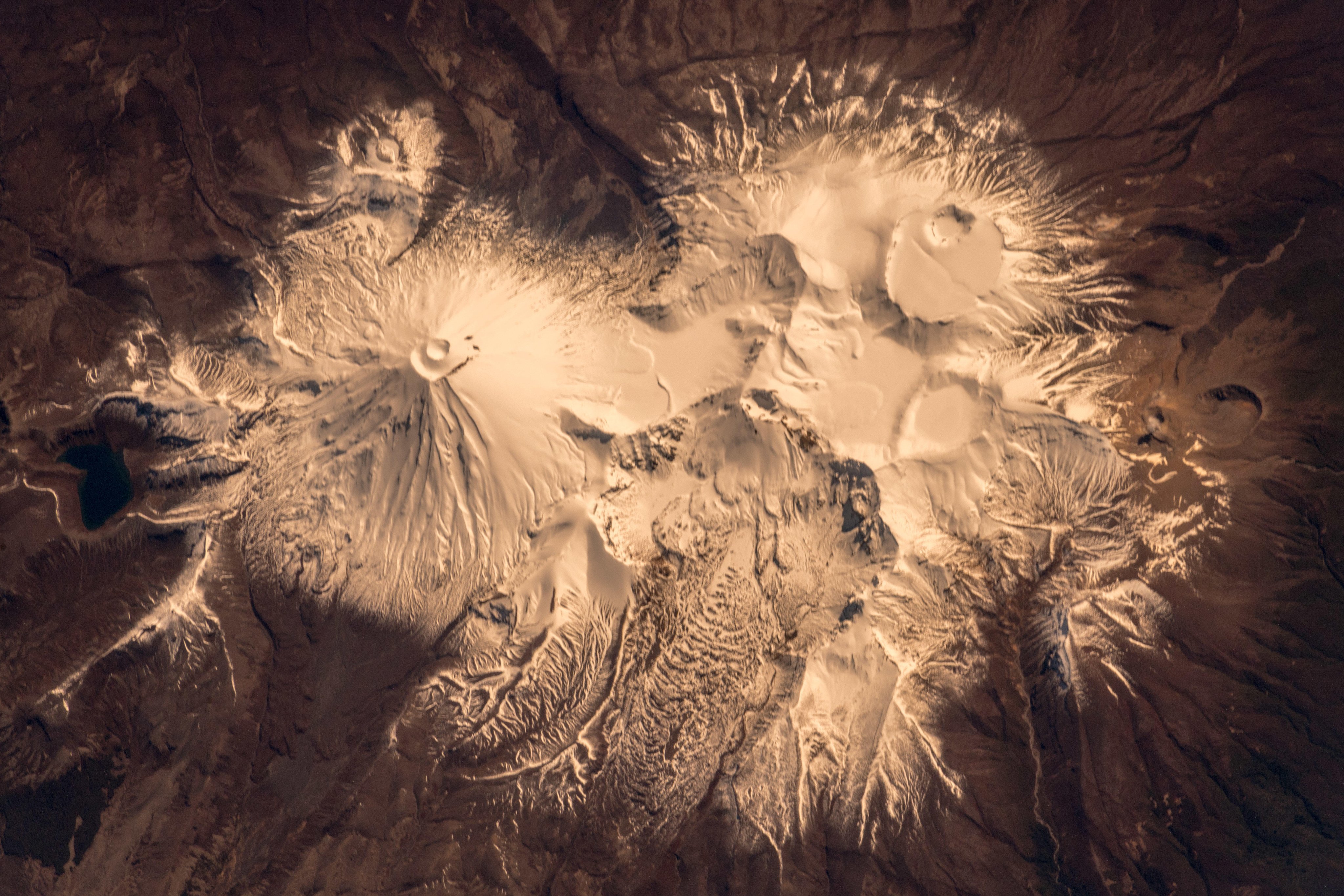
ルアペフ山は、北島のトンガリロ国立公園の中心となる火山で、タウポ湖南岸から約40km南西にあります。3つの峰があり、その一つのタフランギ峰(2,797m)が北島の最高峰です。ルアペフとは、マオリ族の言葉で「音のする穴」「爆発する穴」などの意味があります。ルアペフ山は、1861年以降1997年までに11回噴火しており、最も大きな被害を出した災害は、1953年のものです。1945年の噴火によって火口湖が崩壊しタンギワイの鉄道橋が損傷、警告が間に合わず、通りかかった列車とともに崩落し、多くの命が失われました。
地上の様子はこちらです。

参考文献: Alex Gerst’s Tweet
地球俯瞰画像を見る: LiVEARTH
[Earthview Wonders] No.844: Mt. Ruapehu, New Zealand🇳🇿
Astronaut Alex Gerst captured from ISS Mt. Ruapehu, New Zealand.
Mount Ruapehu is an active stratovolcano at the southern end of the Taupo Volcanic Zone in New Zealand, within Tongariro National Park. The North Island’s major ski resorts and only glaciers are on its slopes. Ruapehu is the highest point (Tahurangi, 2,797m) on the North Island. The 1945 eruption emptied Crater Lake and dammed the outlet with tephra. The crater slowly refilled with water, until on 24 December 1953 the tephra dam collapsed causing a lahar in the Whangaehu River with 151 casualties.
The local scenery on the ground is as follows.
Reference: Alex Gerst’s Tweet
See earthview photo gallery: LiVEARTH[:en][Earthview Wonders] No.844: Mt. Ruapehu, New Zealand🇳🇿
Astronaut Alex Gerst captured from ISS Mt. Ruapehu, New Zealand.
Mount Ruapehu is an active stratovolcano at the southern end of the Taupo Volcanic Zone in New Zealand, within Tongariro National Park. The North Island’s major ski resorts and only glaciers are on its slopes. Ruapehu is the highest point (Tahurangi, 2,797m) on the North Island. The 1945 eruption emptied Crater Lake and dammed the outlet with tephra. The crater slowly refilled with water, until on 24 December 1953 the tephra dam collapsed causing a lahar in the Whangaehu River with 151 casualties.
The local scenery on the ground is as follows.
Reference: Alex Gerst’s Tweet
See earthview photo gallery: LiVEARTH[:]