ルカ・パルミタノ宇宙飛行士がISSから撮影した、アフリカ北西部、モーリタニアの中央部に位置する巨大な環状構造、リシャット構造です。直径は約50kmに及び、宇宙空間からでないとその全容は掴めませんが、その形状から「アフリカの目」、「サハラの目」と呼ばれることもあります。
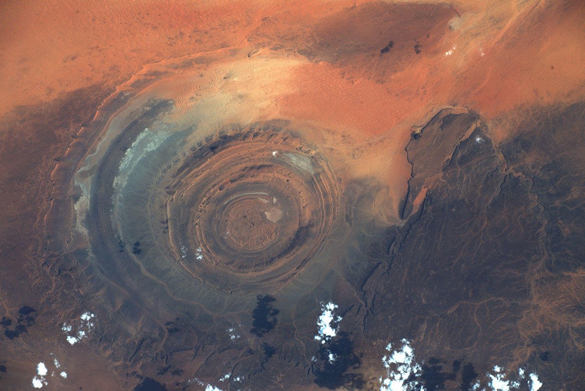
周囲はサハラ砂漠に囲まれ、標高100~200mほどの高台の中に、窪地となったリシャット構造が存在します。構造内部は、同心円上に標高100mほどの山が幾重にも重なっています。発見当初は、隕石の衝突によるクレーターと思われていましたが、調査の結果、特有の鉱物が存在しないこと、直径に比べて深さが浅いことなどから、これは否定されています。山を形成するのはカンブリア紀の固い岩石であり、長年の風化や浸食によって、柔らかい岩石部分が削られ、このような地形が形成されたとされています。また、環状となったのはドーム状の隆起運動のためと考えられています。
地上の様子はこちらです。

参考文献: Luca Parmitano’s Tweet
地球俯瞰画像を見る: LiVEARTH
[Overview the Earth] No.1144: Richat Structure🇲🇷
Astronaut Luca Parmitano captured from ISS the Richat Structurein Mauritania.
The Richat Structure, also called Guelb er Richât (Arabic قلب الريشات Qalb ar-Rīšāt), the Eye of Africa, or Eye of the Sahara, is a prominent circular feature in the Sahara’s Adrar Plateau, near Ouadane, west–central Mauritania, Northwest Africa. It is an eroded dome, 40km in diameter, exposing sedimentary rock in layers which appear as concentric rings. Igneous rock is exposed inside and there are spectacular rhyolites and gabbros which have undergone hydrothermal alteration and a central megabreccia. The structure is also the location of exceptional accumulations of Acheulean archaeological artifacts.
The local scenery on the ground is as follows.
Reference: Luca Parmitano’s Tweet
See earthview photo gallery: LiVEARTH