[:ja]ルカ・パルミタノ宇宙飛行士がISSから撮影したクリミア半島のつけ根の腐海です。西側の幅5-8kmのペレコープ地峡によってユーラシア大陸とつながっていますが、その東は、アゾフ海にかけて極めて浅い干潟のような腐海(スィヴァーシュ)と呼ばれる潟が広がっています。クリミア半島の領有権については、ウクライナとロシアで係争関係にあります。
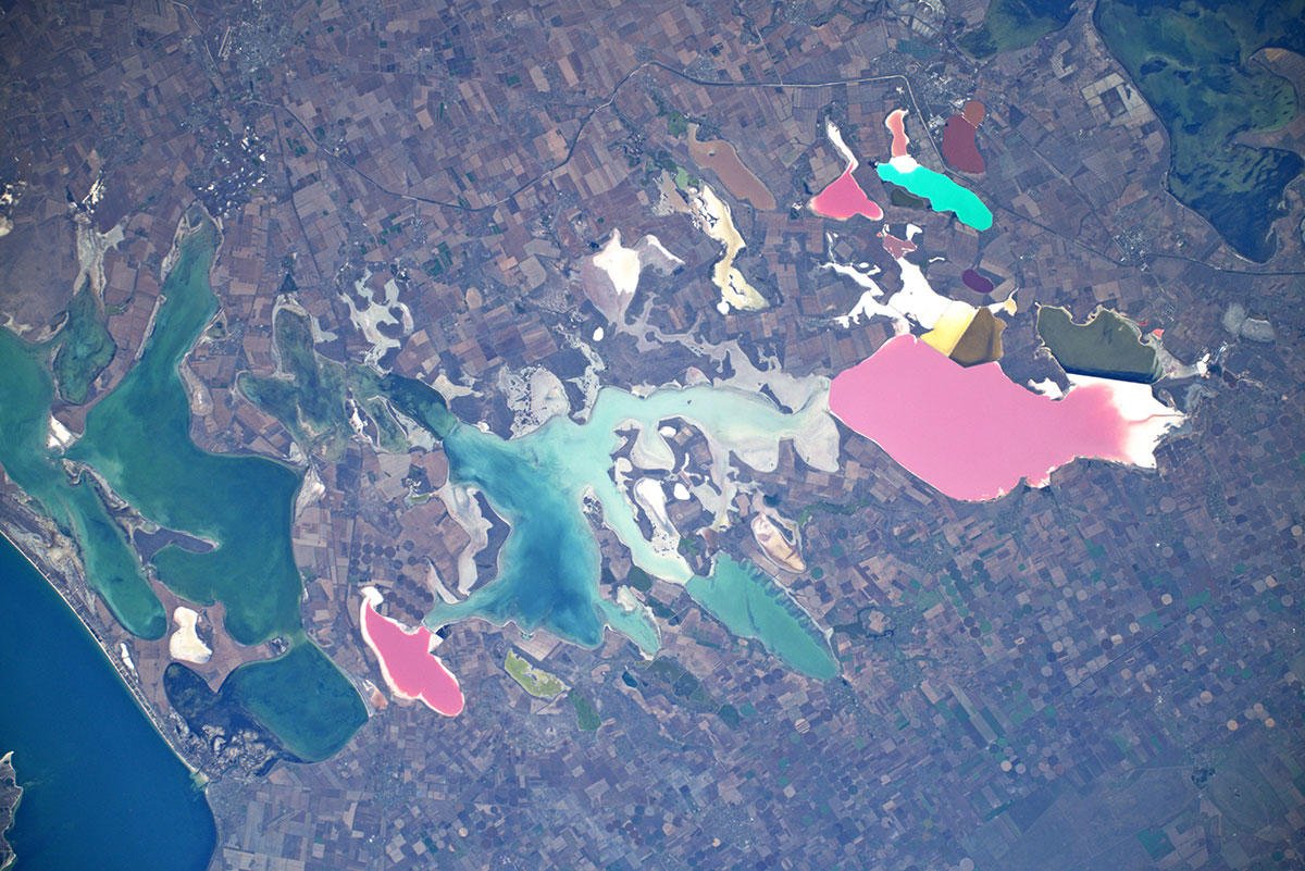
腐海の底質は分厚いシルトから成っており、水深はごく浅く、最深は3.5m程度です。とても浅いために、夏になると腐海の海水は強く熱せられて腐った強くて酷い悪臭を放つようになり、これが、各民族・各国語から「腐った海」・「腐海」を意味する名前で呼ばれる理由になっています。沿岸では、古来より製塩業が発達しています。また、豊富な海塩や無機塩類から、臭素、硫酸肥料、ソーダ灰、塩酸などの化学プラントが建ち並び、地元経済に大きな影響を与えています。
地上の様子はこちらです。ピンク色の藻類が繁殖する腐海では、塩と泥の底がむき出しになっています。

参考文献: Luca Parmitano’s Tweet
地球俯瞰画像を見る: LiVEARTH
[Earthview Wonders] No.1145: Syvash of Crimea
Astronaut Luca Parmitano captured from ISS Crimea (Crimean Peninsula) of which the possession is under dispute between Ukraine and Russia. The peninsula is connected to the Eurasia via 5-8km Isthmus of Perekop where the Sivash or “Rotten Sea”, a large system of shallow lagoons covers.
The Syvash, also known as the Putrid Sea or Rotten Sea, consists of a large system of shallow lagoons on the west coast of the Sea of Azov. The Syvash is extremely shallow. The deepest place is about 3m, with most areas between 0.5-1m deep. The bottom is covered with silt up to 5m thick. Being very shallow, the waters in the Syvash heat up in the summer and produce a putrid smell. The wide area for evaporation also leaves the water extremely salty. The Syvash area is a wetland of international importance. In summer, the water level of Syvash decreases significantly, revealing barren solonets soils called “syvashes” by locals.
The local scenery on the ground is as follows. At the Sivash pink algae fourishes with salt and muddy ground is exposed.
Reference: Luca Parmitano’s Tweet
See earthview photo gallery: LiVEARTH[:en][Earthview Wonders] No.1145: Syvash of Crimea
Astronaut Luca Parmitano captured from ISS Crimea (Crimean Peninsula) of which the possession is under dispute between Ukraine and Russia. The peninsula is connected to the Eurasia via 5-8km Isthmus of Perekop where the Sivash or “Rotten Sea”, a large system of shallow lagoons covers.
The Syvash, also known as the Putrid Sea or Rotten Sea, consists of a large system of shallow lagoons on the west coast of the Sea of Azov. The Syvash is extremely shallow. The deepest place is about 3m, with most areas between 0.5-1m deep. The bottom is covered with silt up to 5m thick. Being very shallow, the waters in the Syvash heat up in the summer and produce a putrid smell. The wide area for evaporation also leaves the water extremely salty. The Syvash area is a wetland of international importance. In summer, the water level of Syvash decreases significantly, revealing barren solonets soils called “syvashes” by locals.
The local scenery on the ground is as follows. At the Sivash pink algae fourishes with salt and muddy ground is exposed.
Reference: Luca Parmitano’s Tweet
See earthview photo gallery: LiVEARTH[:]