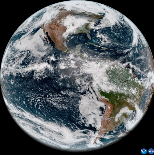
[:ja]2022年5月11日に、米国海洋大気庁NOAAの気象衛星GOES-18(GOES: Geostationary Operational Environmental Satellites)が撮影した初の地球画像が公開されました。GOES-18は、先に打ち上げられているGOES-R(GOES-16)とGOES-S(GOES-17)と基本的に同じ装置を少し改良した6つの観測装置を搭載しています。GOES-18はGOES-17に代わり、静止軌道上の西側の配置となるGOES West(西経137度)衛星として運用する予定です。搭載されているABI (Advanced Baseline Imager)観測装置は青と赤2つの可視バンド、4つの近赤外線バンド、10の赤外線バンドの、計16の波長帯で画像を取得します。
参考文献: Earth from Orbit: NOAA Debuts First Imagery from GOES-18 (NOAA)
地球俯瞰画像を見る: LiVEARTH
[Earthview Wonders] No.1552: First Image of Earth by GOES-18
On May 11, 2022, NOAA shared the first images of the Western Hemisphere from its GOES-18 satellite. The satellite’s Advanced Baseline Imager (ABI) instrument recently captured stunning views of Earth. GOES-18 possesses the ABI which views Earth with 16 different channels, each measuring energy at different wavelengths along the electromagnetic spectrum to obtain information about Earth’s atmosphere, land, and ocean. GOES-18 is the third of the “GOES-R Series”, the current generation of weather satellites operated by the National Oceanic and Atmospheric Administration (NOAA). The current and next satellites of the Series (GOES-16, GOES-17, GOES-18, and GOES-U) will extend the availability of the Geostationary Operational Environmental Satellite (GOES) satellite system until 2037.
Reference: Earth from Orbit: NOAA Debuts First Imagery from GOES-18 (NOAA)
See earthview photo gallery: LiVEARTH[:]