[:ja]NASAの地球観測衛星Landsat 8が撮影したラブラドール海です。グリーンランド最大の都市のヌークも写っています。
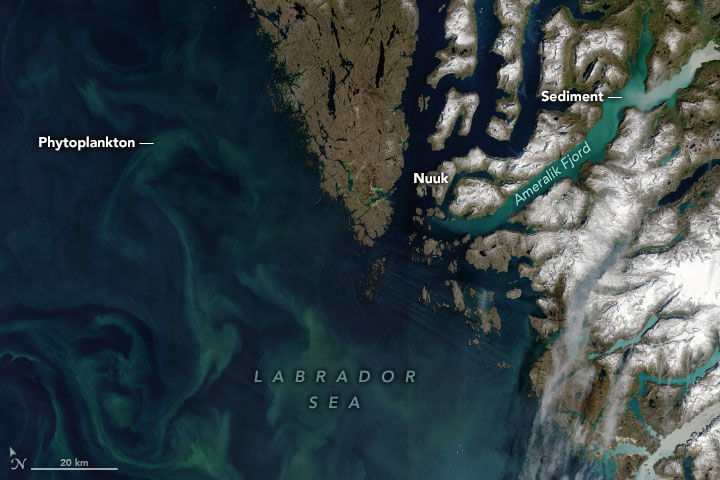
ラブラドル海は、カナダのラブラドル半島とグリーンランドの間にある海です。北はデービス海峡でバフィン湾に、南は大西洋につながっており、大西洋の一部とする考え方もあります。中央部の水深は約3kmあり、南西・北西および北東に大陸棚が連なります。冬は流氷により船舶の航行は困難となります。ラブラドル海の形成は今から約6100万年前に始まり4000万年前に終わった海洋底拡大によるものと考えられています。氷河時代には北アメリカの氷床から流れ出た大量の氷山が流れ込み、それらが溶解することで溶け出した岩石が現在のラブラドル海の底に岩石層を成しています。
地上の様子はこちらです。

参考文献: NASA Earth’s Tweet
地球俯瞰画像を見る: LiVEARTH
[Earthview Wonders] No.1599: Labrador Sea
NASA’s Landsat 8 satellite captured the Labrador Sea. Nuuk, the largest city of Greenland, is also captured in the image.
The Labrador Sea is an arm of the North Atlantic Ocean between the Labrador Peninsula and Greenland. The sea is flanked by continental shelves to the southwest, northwest, and northeast. It is a marginal sea of the Atlantic. The sea formed upon separation of the North American Plate and Greenland Plate that started about 60 million years ago and stopped about 40 million years ago. It contains one of the world’s largest turbidity current channel systems, the Northwest Atlantic Mid-Ocean Channel (NAMOC), that runs for thousands of kilometers along the sea bottom toward the Atlantic Ocean. The Labrador Sea is a major source of the North Atlantic Deep Water, a cold water mass that flows at great depth along the western edge of the North Atlantic, spreading out to form the largest identifiable water mass in the World Ocean.
The local scenery on the ground is as follows.
Reference: NASA Earth’s Tweet
See earthview photo gallery: LiVEARTH[:]