[:ja]サマンサ・クリストフォレッティ宇宙飛行士がISSから撮影したイタリアのポー川です。
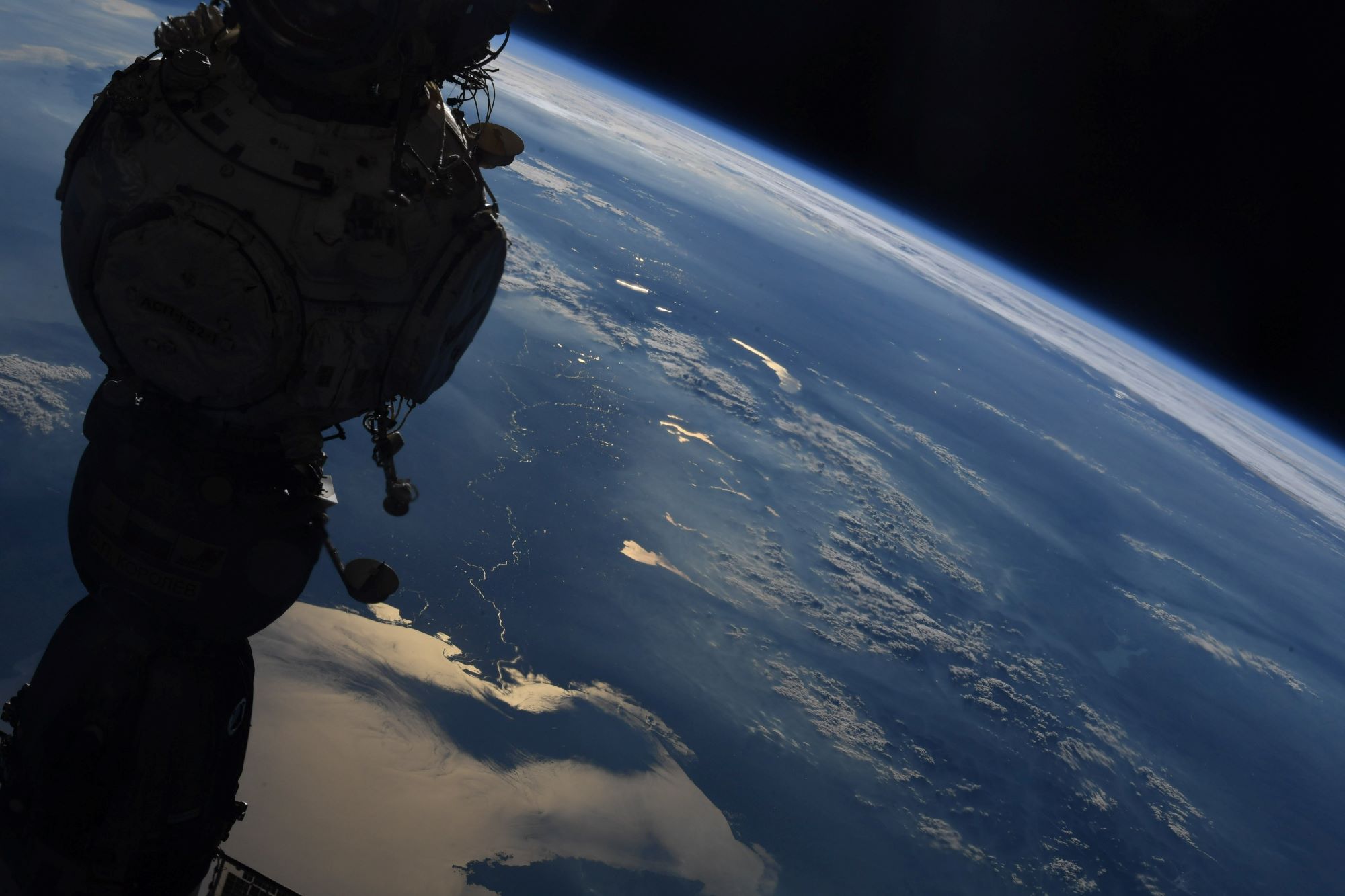
ポー川は、イタリア北部を横断している、イタリア国内で最も長い川(総延長650km超)です。アルプス山脈などに源流を持ち、ロンバルディア平原、ポー平原を流れ、アドリア海に注ぎます。その水はポー川流域にヨーロッパ有数の農産地域を作っている。下流域では、米作が盛んなことで有名です。ポー川河口のデルタ地帯は、1988年に制定された法律に基づいて、ポー川デルタ公園に指定され、環境保護活動が展開されています。ポー川デルタ地帯は、5万3653ヘクタールの公園内に、湿地帯、森林、海辺の砂丘地帯、天然の塩田があり、1000から1100種類の植物と374種類の脊椎動物(内300種以上は鳥類)が生息する生物多様性が展開します。1999年には、「フェラーラ:ルネサンス期の市街とポー川デルタ地帯」として、UNESCOの世界遺産に拡張登録されました。
地上の様子はこちらです。
参考文献: Samantha Cristoforetti’s Tweet
地球俯瞰画像を見る: LiVEARTH
[Earthview Wonders] No.1610: Po River🇮🇹
Astronaut Samantha Cristoforetti captured from ISS Po River, Italy.
The Po with 652km is the longest river in Italy which flows eastward across northern Italy starting from the Cottian Alps. The headwaters of the Po are a spring seeping from a stony hillside at Pian del Re, a flat place at the head of the Val Po under the northwest face of Monviso. The Po then extends along the 45th parallel north before ending at a delta projecting into the Adriatic Sea near Venice. The river flows through many important Italian cities, including Turin, Piacenza, Cremona and Ferrara. Also, the Po Delta wetlands have been protected by the institution of two regional parks in the regions in which it is situated: Veneto and Emilia-Romagna. In 1999 the park was designated a World Heritage Site by UNESCO and was added to “Ferrara, City of the Renaissance, and its Po Delta.”
The local scenery on the ground is as follows.
Reference: Samantha Cristoforetti’s Tweet
See earthview photo gallery: LiVEARTH[:]