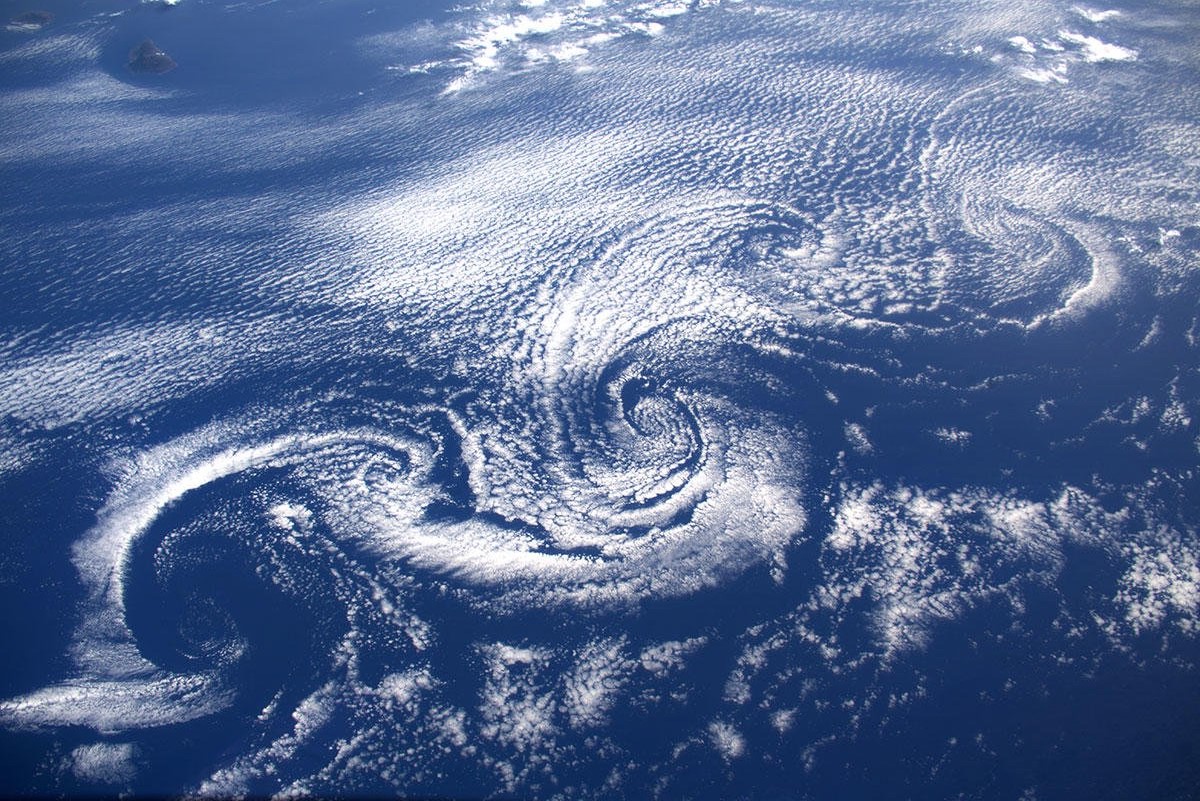
[:ja]ルカ・パルミタノ宇宙飛行士がISSから撮影したアゾレス諸島と近傍のカルマン渦です。カナリア諸島のラ・パルマ島、ラ・ゴメラ島も見えています。
アゾレス諸島は、大西洋の中央部(マカロネシア)に位置するポルトガル領の群島で、リスボンから約1500km、北アメリカの東端から3900kmの位置にあり、9つの島からなります。諸島全体は自治権を持ち、一つの行政区でもあります。西洋文明では、1427年に発見されました。ピコ島の火山ピコ山は標高2351mでアゾレス諸島のみならずポルトガルの最高地点です。捕鯨および遠洋漁業の基地としても使われたほか、現在は温暖な気候から保養地として人気があります。
また、カルマン渦は、流れのなかに置かれた障害物を動かした時、その後方に交互にできる渦の列のことで、自然現象では、この画像のように、島の風下側に雲渦が形成されることがあります。高さ1km付近に顕著な気温逆転層があり、山頂がその上端よりも高く、風向がほぼ一定で比較的強い風が吹くなどの一定の条件がそろうことが重要とされています。ハンガリー人の流体力学者セオドア・フォン・カルマンにちなんで付けられました。
アゾレス諸島のピコ島の地上の様子はこちらです。

参考文献: Luca Parmitano’s Tweet
地球俯瞰画像を見る: LiVEARTH
[Earthview Wonders] No.1113: Azores Islands🇵🇹
Astronaut Luca Parmitano captured from ISS Azores Islands and Karman Vortex nearby. La Palma and La Gomera of Spain’s Canary Islands are also captured in the image.
The Azores is one of the two autonomous regions of Portugal, along with Madeira. It is an archipelago composed of 9 volcanic islands in the Macaronesia region of the North Atlantic Ocean, 1360km west of continental Portugal, and 1500km west of Lisbon. Its main industries are agriculture, dairy farming, livestock, fishing, and tourism, which is becoming the major service activity in the region. Mount Pico, on the island of Pico, is the highest point in Portugal, at 2351m.
Also, as shown in the image, the flow of atmospheric air over obstacles such as islands or isolated mountains sometimes gives birth to von Kármán vortex streets. When a cloud layer is present at the relevant altitude, the streets become visible.
The local scenery on the ground of Pico Island of Azores Islands is as follows.
Reference: Luca Parmitano’s Tweet
See earthview photo gallery: LiVEARTH[:en]Astronaut Luca Parmitano captured from ISS Azores Islands and Karman Vortex nearby. La Palma and La Gomera of Spain’s Canary Islands are also captured in the image.
The Azores is one of the two autonomous regions of Portugal, along with Madeira. It is an archipelago composed of 9 volcanic islands in the Macaronesia region of the North Atlantic Ocean, 1360km west of continental Portugal, and 1500km west of Lisbon. Its main industries are agriculture, dairy farming, livestock, fishing, and tourism, which is becoming the major service activity in the region. Mount Pico, on the island of Pico, is the highest point in Portugal, at 2351m.
Also, as shown in the image, the flow of atmospheric air over obstacles such as islands or isolated mountains sometimes gives birth to von Kármán vortex streets. When a cloud layer is present at the relevant altitude, the streets become visible.
The local scenery on the ground of Pico Island of Azores Islands is as follows.
Reference: Luca Parmitano’s Tweet
See earthview photo gallery: LiVEARTH[:]